Hardy Inlet
The Hardy Inlet provides a beautiful backdrop to the town of Augusta and hamlet of East Augusta, where the mighty Blackwood River joins the sea. The estuary is a playground for residents and visitors, with its protected waters providing a venue for fishing, boating, water skiing and other recreational activities. It provides important habitat for birds, fish and dolphins. Seagrass beds ripple in its shallow waters, and diverse and unique flora line its banks.
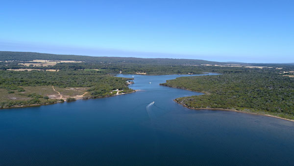
The Hardy Inlet includes the estuarine parts of the Blackwood and Scott rivers to the north-east, which flow into the Hardy Inlet basin (which includes North Bay, West Bay and the lower estuary channel). It opens to the ocean at Flinders Bay and forms ‘the Deadwater’ to the east of the mouth. Marine water travels 42 km up the Blackwood River and 8 km up the Scott River, creating estuarine habitats in the lower rivers. The Blackwood River and Scott River converge around Molloy Island.
The Hardy Inlet basin has an area of 9 km2 and is shallow (depth < 2 m), with a narrow channel to the ocean at one end and a fluvial delta at the other end where the rivers discharge around the small settlement of Molloy Island.
Aboriginal significance
Hardy Inlet is in the boodjar (country) of the Wadandi Noongar people. The area where the Blackwood River turns into Hardy Inlet and runs to Flinders Bay is Talinup, which is named after the Talin or Knob Sedge (Carex inversa), a bush/reed that appears on the estuary shores.
Goorbilyup is the Wadandi name for the lower Blackwood River entering to the estuary, with Goorbilya meaning the large intestine of the stomach.
This is part of the Emu (Waitj) dreaming trail that starts at Lake Dumbleyung and where the town of Wagin gets its name from. It is noted that in modern times Emu oil is considered to promote intestinal health and reduce bowel disease.
*Cultural informants Undalup Association/ Zac and Wayne Webb.