
Our rivers and streams are highly valued for the wide variety of social, cultural, recreational, environmental, and economic services they provide. These include water sports, fishing and marroning, nature-based recreation and ecotourism, and water supply for a range of agricultural, industrial, and urban uses.
A properly functioning ecosystem supporting native biodiversity is critical to maintaining the intrinsic values of rivers and the essential services they provide. However, because of our use of rivers and the development pressures they face, aquatic ecosystems are exposed to significant and increasing stress. Notable impacts include changes to natural flow patterns and connectivity (interrupting species migrations and flushing), poor water quality, reduced instream and fringing vegetation and habitat, and introduction of exotic species (which predate and/or compete with native species and bring disease and parasites).
The more stress our environmental systems face, the less they are able to tolerate and adapt to a changing climate, pressures from expanding and intensifying development, and increased frequency and magnitude of bushfires.
Summary of river health
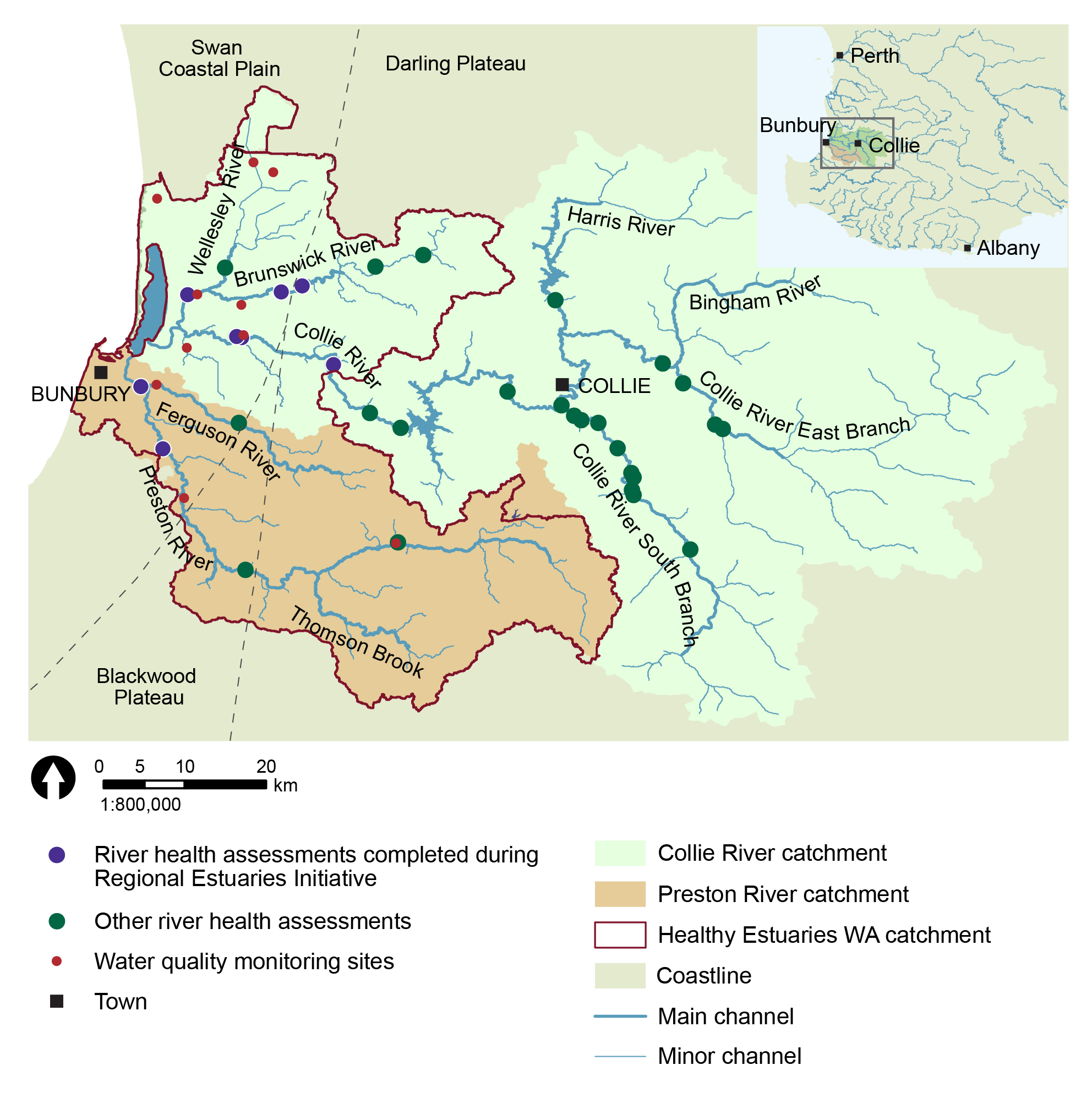
The Leschenault catchment covers a total area of over 3,700 km2 and extends about 100 km inland, with the source of its streams and rivers starting up on the Darling Plateau. Almost 2,000 km2 lies in the Healthy Estuaries WA catchment area and the remainder is the upper Collie River catchment. The catchment includes several river systems: the Brunswick and Wellesley Rivers to the north; the Collie River to the east; and the Preston and Ferguson Rivers to the south. Once the rivers flow off the Darling Plateau, they cross the Swan Coastal Plain to discharge into the Leschenault Estuary, immediately north of Bunbury. The lower Brunswick, Collie and Preston Rivers are all ‘gaining rivers’, meaning that groundwater contributes to their flow.
Since 2008, integrated assessments of river health have been conducted at 40 sites in the Leschenault catchment, under the Department of Water and Environmental Regulation’s (the department) ongoing Healthy Rivers program. This includes targeted assessments during the 2017-20 Regional Estuaries Initiative to investigate key areas of the catchment that previously had little or no data. Some sites have been assessed on multiple occasions to capture seasonal variation. Information from these assessments was examined under the Regional Estuaries Initiative to assess the status of values and threats.
Based on historical data, the Leschenault catchment was found to have reasonably high native biodiversity. A total of 15 native species of freshwater/freshwater-estuarine fish and freshwater crustaceans (crayfish and shrimp) have been found in the Healthy Estuaries WA catchment, including the pouched lamprey, which migrates between the ocean and freshwater. Eleven of these species are endemic to the South West of Western Australia (WA), which means that these species are not found naturally anywhere else.
The department’s standard methods for assessing river health include collecting comprehensive data on water quality, fringing vegetation, flow, land use and aquatic habitat, as well as the aquatic biodiversity, as described in more detail below. The biodiversity status is established by comparing the observed native and exotic species with those expected for each subcatchment, where the expectations are based on historical records. At most sites assessed in the Regional Estuaries Initiative period, almost all of the native fish and crustacean species expected for the subcatchment were found.
However, the river health assessments indicated that there are ongoing pressures and stressors in the system, including:
- clearing of the fringing vegetation, which is arguably the most critical pressure on the functioning of rivers in South-West WA
- erosion of banks resulting in sedimentation (sediment accumulation) impacting aquatic habitat, particularly downstream of areas that have been cleared of native vegetation
- salinisation due to increasing salinity, typically because of rising groundwater table after land clearing brings salts stored in the soil profile into waterways that were otherwise fresh
- on-stream dams and barriers impacting on flow regimes and fish passage
- presence of a variety of exotic species
- eutrophication (nutrient enrichment from excess nutrient run off), contributing to poor water quality such as low dissolved oxygen, and increased incidences of algal blooms and fish kills
Similar systemic pressures and stressors occur in estuaries that are heavily impacted by housing, agriculture, industry and recreation.
Potential water quality issues are ameliorated to some degree by fresh groundwater contributing to streamflow. A lower abundance of native species was observed on the Preston River compared the rest of the system, suggesting some degree of stress. This may be related to sedimentation smothering aquatic habitat, which was more prevalent on the Preston River. High rates of sedimentation are a function of bank destabilisation caused by extensive clearing of native vegetation along the main channel of the upper Preston River, leading to erosion.
Note that the recent assessments were not an exhaustive survey of the current status of the entire catchment, however, the new data now adds to our knowledge base of how WA river systems function in different circumstances. The data also provides a baseline for ongoing monitoring of the health of the rivers in the catchment.
River health assessments
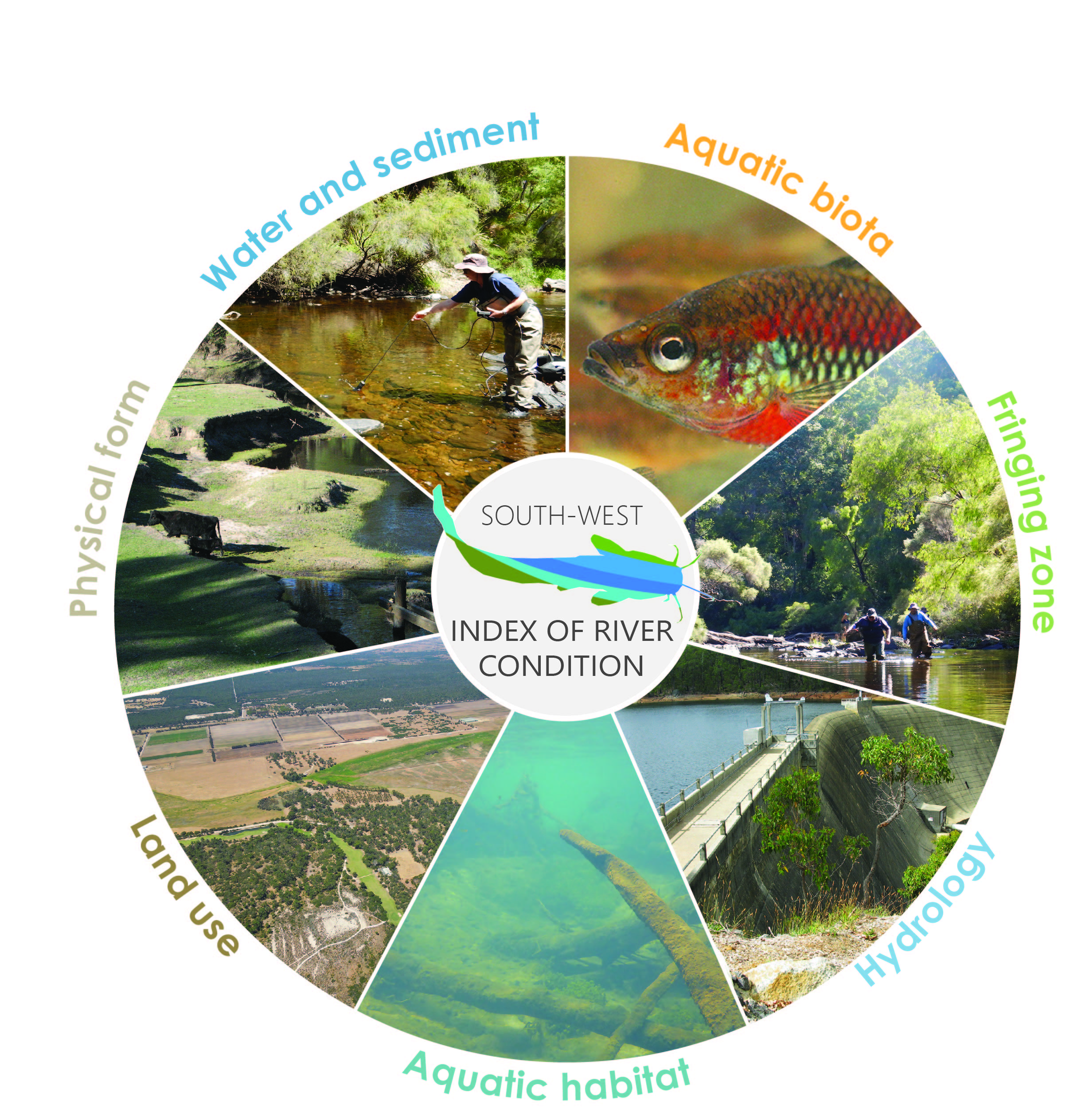 River health assessments were carried out using the
 The Healthy Rivers Program carries out assessments of river health across the South West of Western Australia. This monitoring helps to determine and prioritise management actions, based on values, threats and stressors identified. The assessments also establish a benchmark from which the success of management activities can be determined into the future. All available results can be accessed here.
A total of 40 river health site assessments have been conducted in the Leschenault catchment since 2008, including eight sites assessed as part of the Regional Estuaries Initiative from 2017-20.
The sites assessed in 2017-20 were:
Collie River (Main channel)
Brunswick River (Tributary of the Collie River)
Preston River
Aquatic biota
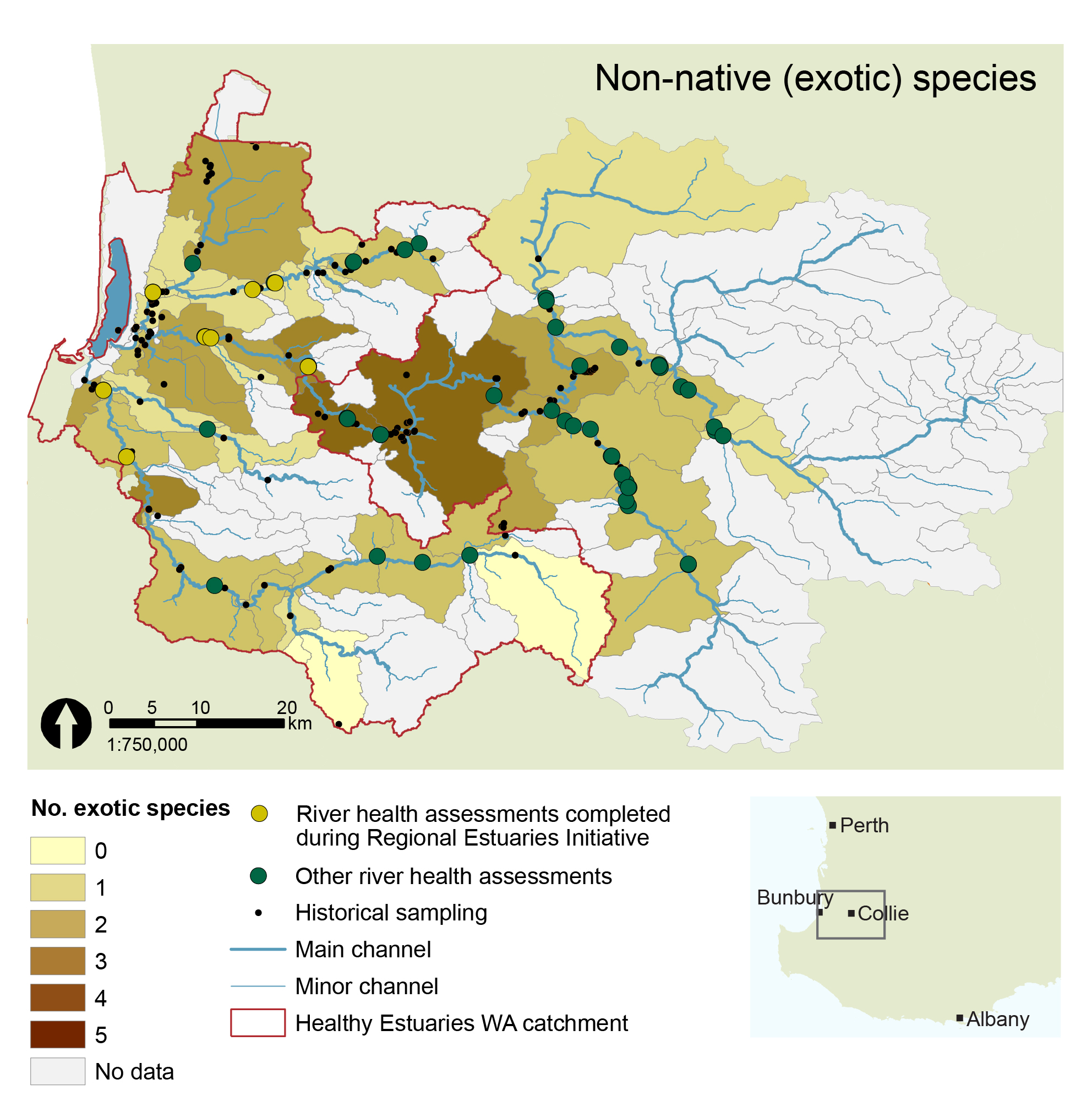
Based on available historical data, 15 native species of freshwater/freshwater-estuarine fish and freshwater crustaceans (crayfish and shrimp) have been found in the Healthy Estuaries WA catchment, two of which are of conservation significance (black-stripe minnow and lamprey). Eleven of these species are endemic to the South West of WA, which means that these species are not naturally found anywhere else. Nine exotic species have been found, as listed below.
Other aquatic or semi-aquatic species recorded include the Rakali, or native water rat, and Carter’s freshwater mussel which is also a species of conservational significance.
A range of exclusively estuarine fish have also been observed including yellow-tail trumpeter, yelloweye mullet, puffer fish, bull shark, Australian anchovy, silver biddy, yellowfin sillago, kingfish, whitebait, Perth herring, tailor and blue sprat.
Native species (Click for more information)
Green border indicates species with conservational significance
Western pygmy perch
Freshwater cobbler
Blue-spot goby
Nightfish
Western minnow
Black-stripe minnow
Western hardyhead
South-west goby
Black bream
Sea mullet
Lamprey
Gilgie
Smooth marron
Restricted gilgie
South-west glass shrimp
Gambusia
Redfin perch
Goldfish
Rainbow trout
Yabby
Common carp
Brown trout

In the river health assessments carried out as part of the 2017-20 Regional Estuaries Initiative, most of the expected (previously observed) native freshwater fish species and crayfish were found in the subcatchments that were sampled, as well as the freshwater-estuarine opportunists, the western hardyhead and sea mullet. Lamprey were not found however this species is not targeted by the standard assessment methods. Two previously observed freshwater-estuarine species were not found in the recent sampling, namely the south-western goby and the southern black bream. However, the absence of these species in the freshwater sections of the catchment is not of concern, as their distribution within rivers is more typically around the lower reaches or within the estuary at the time of assessment.
Carter’s freshwater mussels and Rakali were also observed during the Regional Estuaries Initiative river health assessments.
Seven exotic fish species were recorded across all 2017-20 assessments, including gambusia (mosquito fish), goldfish, carp, rainbow trout, brown trout, and redfin perch. An exotic crayfish, the yabby, was also observed. This species is native to eastern Australia but a pest in WA. The presence of the rainbow trout and redfin perch presents a particular risk to our small-bodied native fish including pygmy perch, minnow and goby species through direct predation.
Overall, in 2019 in the Brunswick and lower Collie catchment, the fish and crayfish populations were abundant and dominated by native species, with fewer than 2% of species recorded being exotics. In contrast, across six sites in the Preston River in 2020, while the diversity of aquatic fauna was maintained compared to previous surveys, the abundances were unexpectedly low. This suggests that the system is under some degree of stress. The loss of abundance but maintenance of richness often relates to an overall decline in habitat availability (quantity), or potentially a general decline in physical water quality conditions (factors that effect a range of species similarly, such as oxygen, salinity and temperature).
Hydrology and landuse
 A large portion of the catchment on the Darling Plateau has retained the native forest (both conservation and managed resources, i.e., state forest), as the land was unsuitable for agriculture. The exception is the upper Preston and Ferguson Valleys, which have been significantly cleared since European settlement. The Swan Coastal Plain has also been cleared extensively for agriculture, with a wide band of intensive and irrigated agriculture from north to south. In cleared areas, the zone of water dependent vegetation surrounding the waterway (riparian zone) is particularly degraded, unfenced and erosion prone, which has impacts further downstream.
Other land uses in the broader catchment include grazing, cropping, urban and infrastructure, and mining (coal in the upper Collie River, and bauxite in the upper Brunswick River).
There are several significant dams/barriers within the Leschenault system, including the Wellington and Harris Dams and Burekup Weir in the Collie River system, the Worsley Dam in the Brunswick River, and the Glen Mervyn Dam in the Preston River system. Water movement (hydrology) has also been altered by the artificial drainage of much of the Swan Coastal Plain to allow agricultural activity, summer irrigation supply and urban expansion. This has resulted in modified flows into the estuary, as well as disruption of natural flows in the catchment, which in turn influences the ecological condition of the rivers. In many of the rivers, the negative impacts of altered hydrology are offset by managed releases from dams, which augment summer flows and maintain water levels in river pools and connectivity for fish migration. The irrigation of intensive agricultural land uses across the coastal plain (see land use map) during summer, via irrigation channels and dam releases, further complicates the hydrology of the catchment.
Vegetation, physical form and habitat

Sites assessed by the Healthy Rivers Program upstream of the Healthy Estuaries WA boundary, on the Darling Plateau, generally displayed a greater extent and quality of fringing vegetation. A more natural meandering channel form exists, largely comprised of native plants and fewer weeds. The banks are stabilised by deep and shallow anchoring root structures from trees, shrubs and ground cover layers.
Clearing for agricultural along the upper reaches of the Preston and Ferguson River system has resulted in reduced vegetation coverage along the river corridor in these areas. The land adjacent to the river health assessment sites on the Swan Coastal Plain has also been largely cleared for agriculture, with scattered trees and only a narrow riparian zone remaining along the riverbank. These severely degraded riparian zones offer little habitat, or protection from predators, for aquatic fauna because of missing overhanging vegetation or woody debris both in and around the water. Furthermore, the lack of stream shading contributes to increased water temperature and lowered dissolved oxygen. The absence of stabilising vegetation also results in active erosion.
 For sites where surrounding land is used for stock grazing, good quality fencing is critical to exclude stock that otherwise would access the river channel. Livestock access to the river results in trampling of banks and exacerbates erosion, increases nutrient levels as their effluent directly enters the waterway, and reduces the shrub and ground cover layers through grazing – all of which are important for ecological function and bank stabilisation.
The river health assessment sites in the upper reaches of the Brunswick River and lower Collie catchments were found to have good aquatic and fringing habitats, whereas conditions are more degraded at sites further downstream in the cleared agricultural areas. The Preston River catchment was mixed with some very degraded aquatic habitats and fringing zones through the agricultural corridor on the Darling Plateau. In this case, more optimal conditions were observed in some of the less disturbed tributaries on the Swan Coastal Plain. The improved habitat was often reflected in greater diversity and abundance of fish and crayfish.
It is likely that groundwater and environmental water releases from dams are maintaining sufficient connectivity and good water quality conditions. These conditions support native fish and crayfish populations; under adverse conditions (low dissolved oxygen and increased water temperatures), exotics species tend to thrive and dominate the ecology.
Erosion of banks leads to downstream sedimentation (accumulation of sediment), which smothers riverbed habitat. Sedimentation was widespread through the assessed sites on the Preston River and was clearly impacting the diversity of aquatic habitat. This was less noticeable on the Brunswick River and lower Collie River, likely due to the consistent flows from groundwater and irrigation releases, which scour out accumulating sediment. The Preston River is also longer and is less altered or impeded by barriers than the other rivers; erosion in the upper catchment followed by relatively free movement of sediment through the system may explain greater accumulation in the lower reaches of the Preston.
Water quality
 Salinity is a water quality concern in the Leschenault catchment. Many of the rivers are already brackish and trending towards higher salinity, largely due to clearing for agriculture. The Preston River is an exception; this system has maintained fresher water due to intact native vegetation in the headwaters of major tributaries, and through inputs of fresh groundwater contributing to the baseflow of the river.
Dissolved oxygen and water temperature were maintained in ranges that are not likely to cause stress to native aquatic fauna. This was somewhat unexpected where streamside vegetation is degraded due to reduced stream shading, which often leads to increased water temperatures and lower dissolved oxygen. However, it is likely that groundwater and or irrigation releases entering the Collie, Brunswick and Preston Rivers on the Swan Coastal Plain aid in maintaining the dissolved oxygen concentrations and buffering water temperatures.
Nutrient intensive land uses in the catchment, particularly in the irrigated zone on the Swan Coastal Plain and the upper Preston, have resulted in poor water quality and increased algal growth in the lower reaches of the major rivers and in agricultural drains. This presents an ongoing risk to the health of the Leschenault Estuary. Nutrient enrichment can lead to increased frequency and severity of harmful algal blooms and fish kill events. Both these effects are longstanding issues in the estuary and lower reaches of the rivers in the catchment. Of the 21 fish kills reported to the department between April 2016 to September 2020 across all six Regional Estuaries Initiative catchments, four occurred in the Leschenault catchment, all in the lower, tidally influenced reaches of the Collie River.
Longer-term water quality monitoring is carried out at a range of sites across the catchment, see a more detailed summary of seasonal and longer-term trends in nutrients, salinity, pH, and total suspended solids.