
Our rivers and streams are highly valued for the wide variety of social, cultural, recreational, environmental, and economic services they provide. These include water sports, fishing and marroning, nature-based recreation and ecotourism, and water supply for a range of agricultural, industrial, and urban uses.
A properly functioning ecosystem supporting native biodiversity is critical to maintaining the intrinsic values of rivers and the essential services they provide. However, because of our use of rivers and the development pressures they face, aquatic ecosystems are exposed to significant and increasing stress. Notable impacts include changes to natural flow patterns and connectivity (interrupting species migrations and flushing), poor water quality, reduced instream and fringing vegetation and habitat, and introduction of exotic species (which predate and/or compete with native species and bring disease and parasites).
The more stress our environmental systems face, the less they are able to tolerate and adapt to a changing climate, pressures from expanding and intensifying development, and increased frequency and magnitude of bushfires.
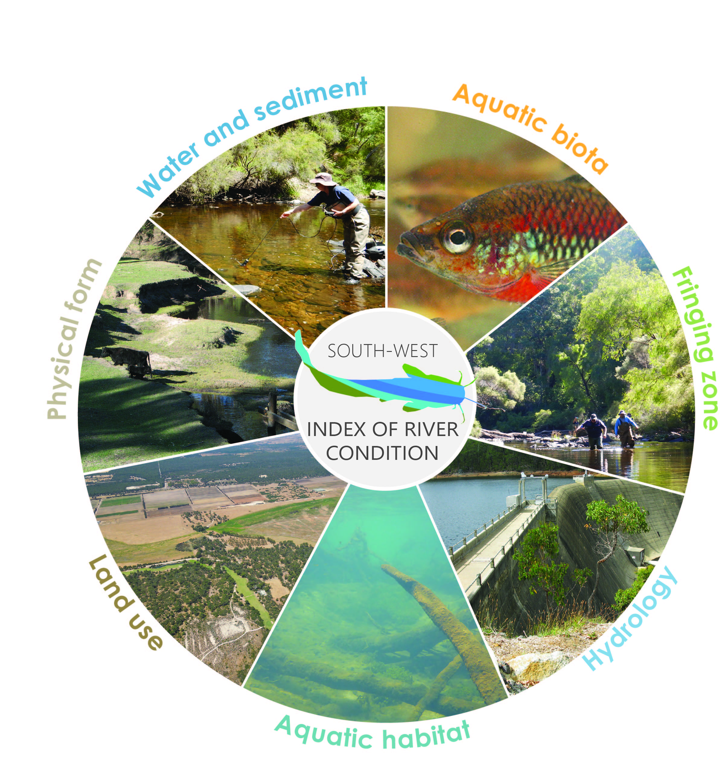
Summary of river health
Since 2012, integrated assessments of river health have been conducted at about 30 sites in the Lower Blackwood and Scott River catchments under the department’s ongoing Healthy Rivers program. This includes targeted assessments during the 2017–20 Regional Estuaries Initiative to investigate key areas of the catchment that previously had little or no data. Some sites have been assessed on multiple occasions to capture seasonal variability or other changes over time. Information from these assessments was examined under the Regional Estuaries Initiative to assess the status of values and threats.
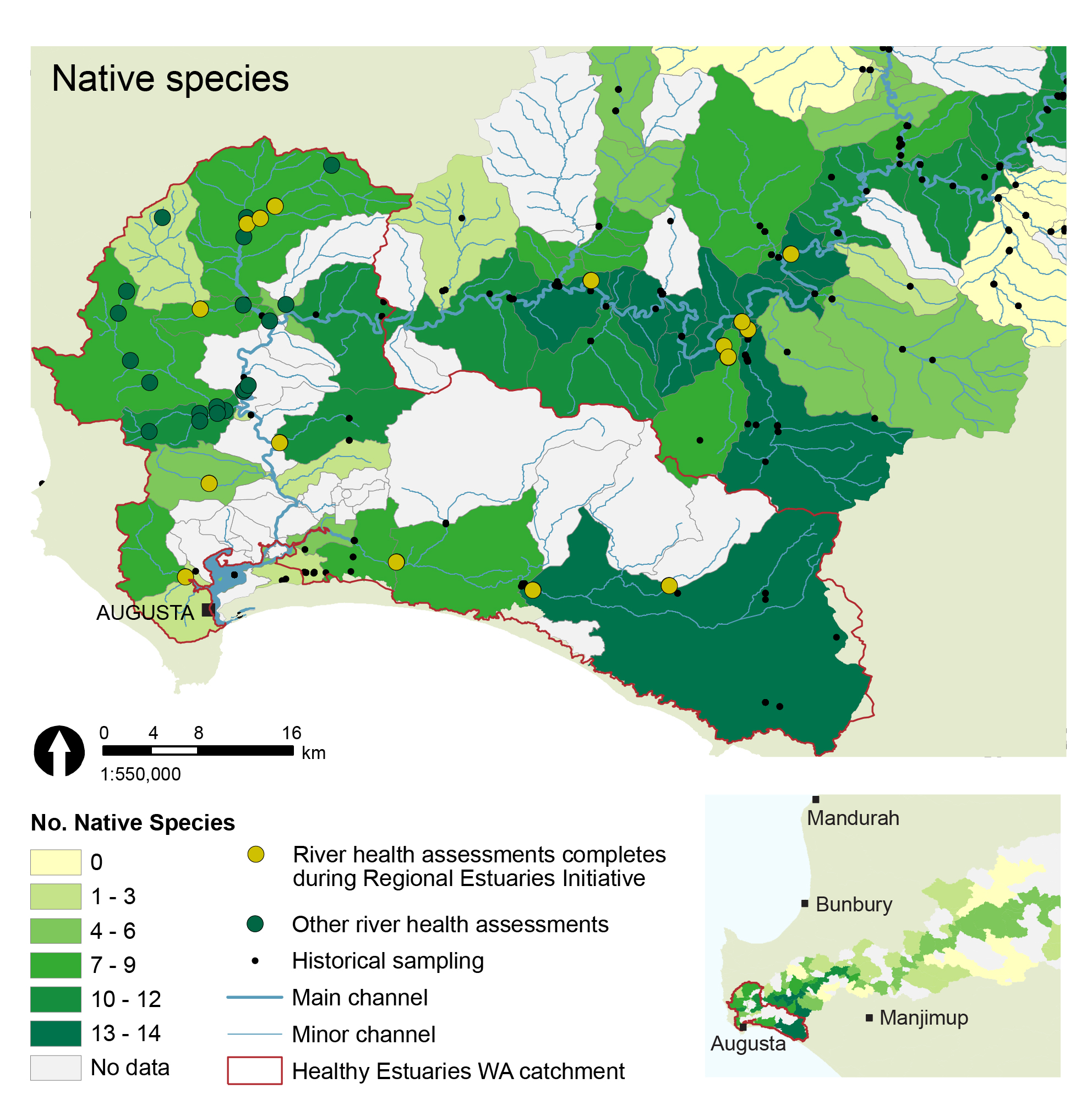
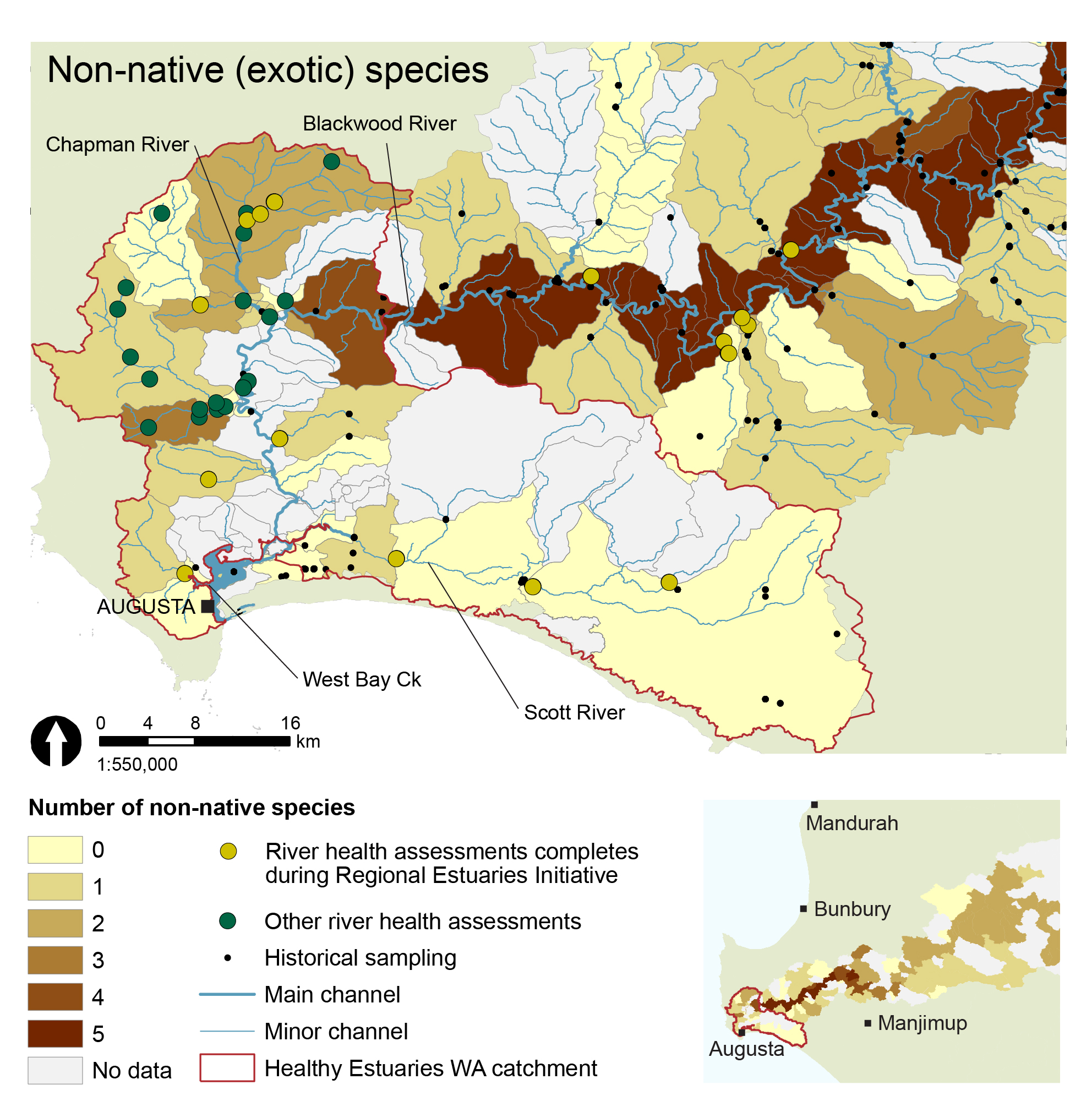
This work, and previous surveys established that there are high ecological values across the Healthy Estuaries WA catchment. Of particular note was a remarkably high diversity of native aquatic biota (fish and crayfish). Eight species of freshwater fish, five freshwater crustaceans (crayfish and shrimp), and five estuarine-freshwater fish have been found in the region, as well as the pouched lamprey, which migrates between the ocean and freshwater. Fifteen of these species are endemic to the South West region of Western Australia (WA), which means that they are not naturally found anywhere else. Carter’s freshwater mussel has also been observed. This biodiversity represents one of the highest observed in a river system across the South West.
The department’s standard methods for assessing river health include collecting comprehensive data on water quality, fringing vegetation, flow, land use and aquatic habitat, as well as the aquatic biodiversity, as described in more detail below. The biodiversity status is established by comparing the observed native and exotic species with those expected for each subcatchment, where the expectations are based on historical records. Almost all of the native fish and crustacean species expected for the subcatchment were found at most of the sites assessed in the Regional Estuaries Initiative period.
The assessments also highlighted ongoing pressures and stressors impacting river health in some parts of the system, including:
- low dissolved oxygen at some sites
- input of excess nutrients and sediment at some sites, related to agriculture land use with livestock access and clearing of vegetation, leading to decline in water quality, macroinvertebrate health, and aquatic habitat
- presence of non-native fish and crayfish species
- presence of exotic plant species in the fringing zone vegetation
- reduced flows, leading to loss of summer refuge habitat because of less total area and poorer water quality.
Note that the recent assessments were not an exhaustive survey of the current status of the entire catchment; however, the new data adds to our knowledge base of how WA river systems function in different circumstances. The data also provides a baseline for ongoing monitoring of the health of the rivers in the catchment.
River health assessments
 River health assessments were carried out using the
 The Hardy Inlet Healthy Estuaries WA catchment is comprised of the Lower Blackwood and Scott River catchments. River health assessments conducted throughout 2017–19 as part of the Regional Estuaries Initiative are summarised below.
Before this, 20 sites were assessed between 2012 and 2013, including sites in the lower Blackwood River, Chapman and Upper Chapman brooks, and the McLeod, Rushy and Fisher creeks. Report cards were also published for each system One additional site in the catchment has been assessed for biota only.
Chapman and Upper Chapman Brooks:
In February 2016 and 2019, four sites were assessed on Chapman Brook and Upper Chapman Brook (tributary of the Lower Blackwood River):
These sites were sampled again in May/June 2020; data from this latest field work is being processed.

Lower Blackwood tributaries:
Three site assessments were carried out in October 2017 within two small tributaries of the lower Blackwood, and one tributary flowing directly into Hardy Inlet:
- West Bay Creek (tributary of the Hardy Inlet)
- Glenarty Creek (tributary of the lower Blackwood River)
- Wall Road (unnamed tributary of the lower Blackwood River).
Scott River:
Three site assessment were conducted in October 2017 within the Scott River system:
Aquatic biota
The Hardy Inlet catchment supports valuable biological diversity. Based on data collected to date, 19 species of native freshwater/freshwater-estuarine fish and freshwater crustaceans (crayfish and shrimp) have been found in the Lower Blackwood and Scott River catchments. This includes two estuarine species that opportunistically enter the freshwater parts of rivers to forage, the pouched lamprey which migrate from the ocean into the headwaters of rivers to spawn, four species of freshwater crayfish and one species of freshwater shrimp. Fifteen of these species are endemic to South West WA; that is, they are not found anywhere else. Five species are of conservation significance including black-stripe minnow, mud minnow, Balston’s pygmy perch, salamanderfish, and pouched lamprey. Five exotic fish species have been found, and one exotic crayfish (yabby).
Native species (Click for more information)
Green border indicates species with conservational significance
Western pygmy perch
Blue-spot goby
Nightfish
Western minnow
Western mud minnow
Black-stripe minnow
Salamander fish
Balston's pygmy perch
Freshwater cobbler
Western hardyhead
South-west goby
Black bream
Sea mullet
Jollytail
Lamprey
Gilgie
Smooth marron
Koonac
Restricted gilgie
South-west glass shrimp
Gambusia
Yabby
Redfin perch
Goldfish
Common carp
One-spot livebearer
Scott River and catchment – October 2017
In the 2017 river health assessments within the Scott River catchment, a diverse community of native aquatic fish and crayfish were found at the two sites, and no exotic species were found. In addition, the observation of juveniles of most species and gravid (egg carrying) females indicates successful breeding and viable populations.
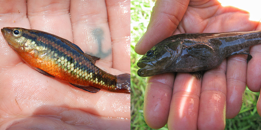
Signs of breeding at Brennans Ford: ‘Nuptial colours’ (occurs during breeding season) in western pygmy perch (left) and a gravid nightfish (right).
Salamanderfish, black stripe minnow, mud minnow and koonac have previously been found in the subcatchment of the Milyeannup Bridge site but were not found in this assessment. These species have habitat preferences, preferring off-channel wetlands and minor tributaries. They would not necessarily be expected at the specific study sites but more likely to occur in smaller tributaries and wetlands in the catchment.
Importantly, Balston’s pygmy perch (Nannatherina balstoni) were found at the Milyeannup Bridge site. This species is listed as ‘Vulnerable’ under both the Biodiversity Conservation Act 2016 (WA) and Environment Protection and Biodiversity Conservation Act 1999 (Australia).
The key threats to N. balstoni are:
- habitat alteration particularly through declining river flows, salinisation and eutrophication
- physical habitat destruction from development
- predation and competition from exotic species
The Scott River population is important because of the limited distribution of the species. It is restricted to near-coastal streams, lakes and wetlands between upper Margaret River, the Goodga River near Albany, and only within localised areas within this range.
The high ecosystem values at the two sites on the Scott River are likely supported by the extensive, intact and healthy fringing vegetation. The adjacent land use included cattle grazing but at both sites the river was fenced off from livestock, and there was abundant and diverse aquatic habitat. Water quality was largely within optimal ranges at both sites, except for total phosphorus, which exceeded ANZECC 2000 guidelines (see Water Quality ).
In contrast, the Four Acres site, on an upper tributary of the Scott River, was in poor ecological health. The site is in the same subcatchment as Milyeannup Bridge, with 13 species known in the catchment. Only one individual fish which had perished in a trap and only four freshwater crayfish (gilgie) were found at the Four Acres site. The site is a small tributary and it is possible that some of the expected species for the catchment would not naturally occur. This still represents a significant decline is the community that would exist naturally.
Fringing vegetation at the Four Acres site was degraded with no trees, minimal shrubs, and a ground layer of predominantly exotic grass. The water quality was very poor with all variables failing to meet the recommended guideline values. In particular, dissolved oxygen was anoxic (near zero) and nutrient levels were excessive, indicating excess input from surrounding agriculture. Optimal oxygen conditions for South West fish species are generally expected to be over 5 mg/l, and concentrations below 4 mg/L are known to elicit stress in most fish species, with levels below 2 mg/L resulting in rapid mortality. The deceased fish found in the trap is evidence of poor water quality, wherein the individual is likely to have been moving through poorer water quality areas to forage or seek better quality habitat when trapped. It is likely any fish in the area would survive in only limited habitat close to the surface of the water where a thin lens of higher oxygen exists because of contact with the air. The dissolved oxygen levels alone would explain . The lack of sufficient fringing vegetation also deprived the instream environment of shading and habitat.
West Bay Creek – October 2017
This site has high ecological value, as demonstrated by a healthy and diverse range of native aquatic biota, with evidence of successful recruitment, and only one exotic species. Additionally, it had good aquatic habitat, relatively good water quality and good coverage of fringing vegetation.
Lower Blackwood River tributaries – October 2017
Assessment of two sites (Glenarty Creek and Wall Road) on the lower Blackwood in Oct 2017 revealed slightly lower native species richness than some other sites; however, given that these were small, isolated tributaries, this may reflect natural communities (as no previous information was available on the systems). The species present were recorded in high abundances, and only two exotic species were found, the yabby and Gambusia holbrooki.
The fringing vegetation was either good quality or improving because of revegetation, which was stabilising banks and improving shading. However, continued improvements such as restricted stock access, limiting fertiliser use and additional revegetation would further improve habitat, water quality and ecological health.
An exciting find was the burrows of what is expected to be Augusta burrowing crayfish (Engaewa similis), which is not normally captured with the SWIRC sampling methods (see below).
Chapman and Upper Chapman Brook – February 2019
A diverse community of native aquatic fish and crayfish were found in Chapman and Upper Chapman Brook sites, with only one individual exotic fish (Gambusia holbrooki). Juveniles of most species were found at most sites, as well as other indicators of breeding. The site with fewest juveniles was the Chalice Bridge site, despite relatively high abundances of fish. This indicates that although this site offers excellent summer refuge, it is not providing a spawning/nursery habitat. Furthermore, there was limited refuge for fish to hide in and fish could easily be seen schooling. This seemed to be because of the low amount of refuge along the banks, such as overhanging shrubs, rushes, and the reduced abundance of woody debris. As such, the lack of juveniles may represent a degradation in habitat from natural conditions.
At the two upstream sites the mud minnow was found in relatively high abundance (~20 individuals) which is high for this species compared with other sites within its known range. This is of ecological significance as this species is listed as 'Vulnerable’ under the WA Biodiversity Conservation Act 2016 and is typically only found in low abundances within its natural range.
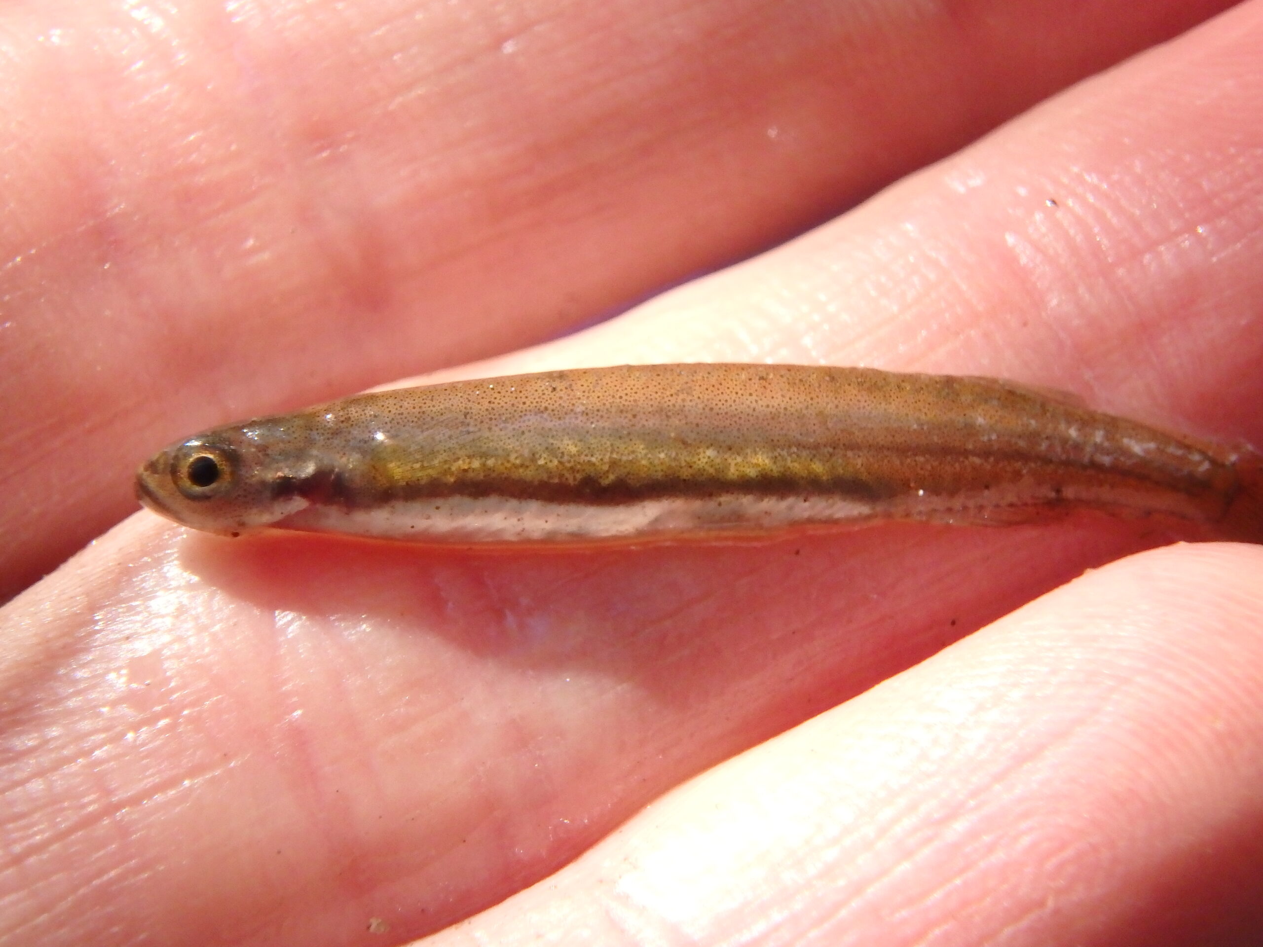
A Galaxias munda (mud minnow) found upper Chapman Bk (Berry Farm)
Other species in the catchment
Other species of ecological significance found in the catchment include:
- Carter’s freshwater mussel (Westralunio carterii), listed as ‘Vulnerable’ in WA and Australian Acts.
- Rakali (Hydromys chrysogaster). Although rakali, or water rat, are common and widespread throughout Australia, there have been declines locally because of loss and degradation of streamside habitat, salinisation, drying largely because of climate change, and predation by introduced species such as cats and foxes. It is currently a protected species under the Biodiversity Conservation Act 2016 (WA).
See more information on each of the species.
Hydrology and landuse
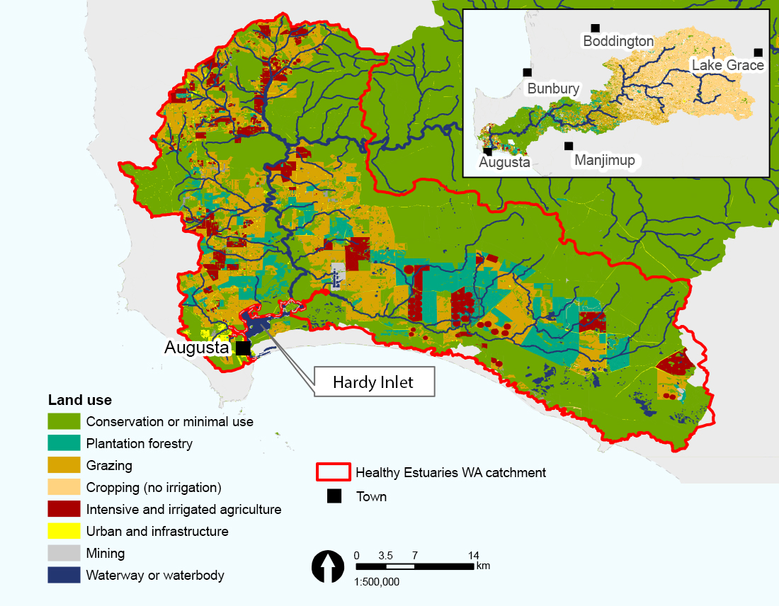 The Blackwood River is 300 km long and accounts for almost 90 per cent of the flow into the Hardy Inlet. For purposes of the summary below, the Blackwood River catchment is divided into a lower, middle and upper catchment. The Hardy Inlet Healthy Estuaries WA catchment is focused on the lower Blackwood and the Scott River catchments (see map).
Most of the flow within the Blackwood River originates in the Lower Blackwood catchment, where rainfall is the greatest. Groundwater also flows into the Blackwood from the Yarragadee Aquifer.
The Scott River joins the Blackwood River just above the Hardy Inlet. The Scott River contributes 7 per cent to the total annual flow into the Hardy Inlet. The river is 35 km long and flows parallel to the coast along the southern portion of the catchment.
Several tributaries flow directly into the Lower Blackwood River, including Chapman and Upper Chapman Brooks, and the McLeod, Rushy, Fisher and Glenarty Creeks.
The major tributaries flowing into the middle Blackwood are the Mullalyup Brook, Hester Brook, Gnowergerup Brook, Four Mile Gully, Dinninup Brook and Boyup Brook.
In the upper Blackwood River catchment, there are chains of naturally occurring salt lakes and wetlands, including the RAMSAR-listed Lake Toolibin in the north and a southern chain of lakes running from Dumbleyung to south of Wagin. As a result of low annual average rainfall and flat topography, these systems only contribute flow into the lower Blackwood River during extreme rainfall events.
Extensive clearing has occurred within the upper Blackwood catchment for agriculture and, as a result, only 16% of remnant vegetation remains. In the upper subcatchment there is predominately broadacre cereal cropping and sheep grazing. These land uses have led to nutrient enrichment, dryland salinity and disturbance of acid sulphate soils. Land use in the lower and middle Blackwood catchments is predominately intensive horticulture, grazing, viticulture, dairy and beef farming, and milling for timber. Fringing vegetation coverage and type is discussed in the next section.
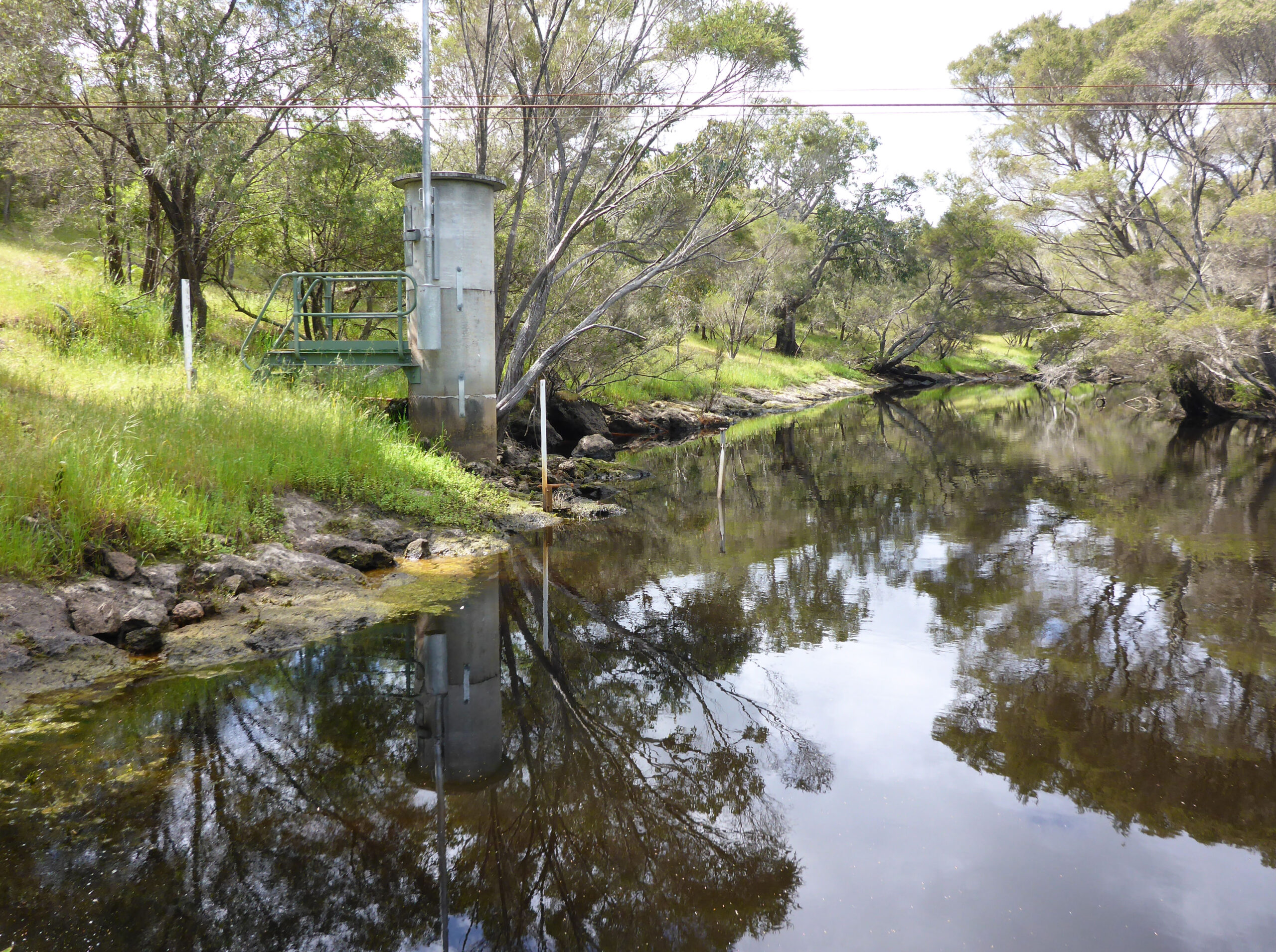
Gauging station at Brennans’s Ford, Scott River
Vegetation, physical form and habitat
The natural vegetation in the Blackwood basin is varied, and corresponds to changes in soils, climate and physical geography. There is low scrub in the lower catchment near the coast, through to karri and jarrah forests in the lower-middle catchment, and mallee and shrubs in the east (middle to upper catchment) where rainfall is lower.
Extensive clearing has occurred within the upper Blackwood catchment for agriculture and, as a result, only 16% of remnant vegetation remains. The lower Blackwood catchment has the most vegetation cover and the native vegetation is the least fragmented, with about 70 per cent of the catchment covered by native vegetation. The middle catchment is about 40 per cent native vegetation.
Scott River
Unlike many other catchments in the South West, native vegetation still covers most of the Scott River catchment, comprising 31 different vegetation complexes that contain many rare and priority plant species. A 2005 desktop assessment showed that almost 100 per cent of the Scott River was vegetated to an average width of almost 50 m on both sides of the channel.
Common fringing vegetation species along the Scott River include melaleuca, peppermints, tea trees and the native typha. This is consistent with data collected at the two sites assessed in October 2017. The assessments also highlighted excellent structural integrity of riverbanks, minimal signs of erosion and a range of in-stream habitat types and complexity. The trees in the streamside vegetation also provided good shading and refuge to the aquatic zone.
The Four Acres Road site appeared to have been historically realigned and straightened, likely to accommodate the adjacent road infrastructure. The vegetation within the streamside zone (first 10 m on each bank) was significantly modified, with no trees, minimal shrub layer, and a ground layer consisting of largely exotic grasses and dock weed.
West Bay Creek
The streamside zone at the assessment site on West Bay Creek was well vegetated with all three structural layers of groundcover, shrubs and trees present in high densities. The fringing vegetation was wide, at about 30 m. This streamside vegetation provided shade and cover across most of the stream width. However, a significant portion of the ground and tree layer was exotic grasses and fig trees. The vegetation 10–100 m from the river was mostly native but did include some exotic species. The banks had excellent structural integrity with minimal signs of erosion.
Chapman and Upper Chapman Brook
A 2012 desktop assessment showed fringing vegetation covered almost 100 per cent of the upper reach of Upper Chapman Brook to an average width of 50 m. The middle section varied between 24–65 per cent of the river length vegetated, with an average width of up to 20 m. The 2019 field assessments found similar vegetation coverage, with up to 50 per cent coverage of trees in the streamside zone. Species consisted of peppermints, acacia, tea-trees, bracken fern, sedges and rushes. Shrub and ground layers varied from 10–75 per cent cover, but much of the groundcover was exotic, except for in the upper reach where few exotics were found. In all assessed sites exotic species were low or absent in the shrub and tree layers. Some erosion of the banks was observed, as low as 5 per cent but up to 50 per cent of the bank length in some areas.
Fringing vegetation occurred along about 50 per cent of Chapman Brook at an average width of 22 m. This was reflected in wide and intact fringing vegetation seen at the assessed sites. There was minimal exotic species observed at the sample sites, except in the upper catchment where there was a high proportion of exotic species in the shrub layer because of the presence of blackberry and thistles. However, at a site lower down in the catchment there was a dense shrub layer of tea-trees and with few exotics; beyond this zone was a band of jarrah and marri trees. Erosion was minimal at all assessment sites and the banks had good structural integrity.
Lower Blackwood River and other tributaries
In the Lower Blackwood catchment upstream of the intersection with the Chapman Brook, a 2005 desktop assessment showed that the vegetation was slightly modified compared with pre-European conditions. Below this, about 75 per cent of the channel was vegetated to a width of about 30 m on each bank (2012 desktop study).
At the Glenarty Creek site, west of the main Lower Blackwood River channel, the vegetation within the streamside zone was poorer quality, with less than 10 per cent tree coverage, and the shrub layer was moderately altered with less than 50 per cent coverage of native species. Although the groundcover was dense, it consisted largely of exotic grasses. Accordingly, the creek had limited shading, reduced input of woody debris to support shelter and food webs with minimal protection from erosion.
At the Wall Road Creek site, east of the main channel, the vegetation within the streamside zone included a ground, shrub and tree layer, in relatively good condition. The tree layer was entirely native and included marri and paperbark, and the groundcover was native rushes and sedges.
Water quality
Scott River and catchment
At the time of sampling of the Milyeannup and Brennan’s Ford sites (October, 2017), total phosphorus was slightly above the ANZECC (2000) guideline (expected) value for slightly disturbed river ecosystems in South West WA, and total nitrogen was slightly below the guideline value. The pH at Milyeannup was just below the ANZECC southern-WA default trigger value guideline (lower limit) for lowland rivers; however, this is only a guideline value for South West WA rivers, and slightly acidic waters are not uncommon in natural waterways within this region. All other water quality parameters, including dissolved oxygen, temperature and turbidity, were within acceptable ranges.
In contrast, at the Four Acres Tributary site (on a tributary of the upper Scott River) total phosphorus and total nitrogen were both much higher than found naturally in streams in South West WA. The water was anoxic (near-zero dissolved oxygen), which is insufficient to support fish populations. The low oxygen is likely a result of very high biological oxygen demand, resulting from excess organic and inorganic nutrient loading from surrounding agriculture. The lack of fringing vegetation and the construction of drains to reduce surface water ponding means nutrients can be rapidly washed from soils to waterways and be transported downstream quickly, rather than being assimilated.
The point measurements taken through Healthy Rivers at these three sites were consistent with longer-term water quality monitoring, which occurred either at the site or nearby. The longer-term monitoring indicates that concentrations vary seasonally and between years, and that nutrient guideline values are exceeded at other times of the year.
West Bay Creek
At West Bay Creek in October 2017, total phosphorus and total nitrogen were both below the ANZECC (2000a) trigger values for South West WA. Dissolved oxygen, temperature, salinity, turbidity and pH were recorded as daytime spot measurements on this occasion; values were within the expected normal ranges.
Water quality varies throughout the year as described in a more detailed summary of seasonal and long-term water quality trends near this site.
Lower Blackwood River tributaries
In October 2017, the nutrient concentrations at Wall Road Creek were at or slightly above the ANZECC (2000) trigger values for South West WA, whereas concentrations at Glenarty Creek were below.
At Glenarty Creek in October 2017, the temperature variation over the day was slightly greater than the upper limit expected for most natural systems in the south-west of WA. This is likely associated with the reduced fringing vegetation.
Other water quality parameters including dissolved oxygen, temperature, pH, salinity, and turbidity were within acceptable ranges. However, it should be noted that sampling was carried out in spring; higher temperatures and lower dissolved oxygen would be expected in summer. Nearby, longer-term monitoring of a range of water quality parameters indicates that nutrient concentrations at both sites vary over the year and between years.
Chapman Brook and Upper Chapman Brook
On the Upper Chapman Brook, samples taken during river health assessments in February 2019 (above the confluence with the Chapman Brook) showed nutrient concentrations were low at all three sites. At two of the sites, dissolved oxygen concentrations were low (average was 4–5 mg/L over a 24-hour period). These dissolved oxygen levels are not uncharacteristic in South West streams in late summer; however, they should be monitored as levels below this can put stress on fish and other aquatic biota. Other water quality parameters including turbidity, temperature and salinity were within acceptable ranges.
At the site on the Chapman Brook, Forest Grove Pool, the mean dissolved oxygen over the 24-hour sampling period (February 2019) was 3.75 mg/L. This value falls below the lower guideline limit of 4 mg/L used in the South West Index of River Condition. However, the long-term water quality logger showed dissolved oxygen tended to improve from mid-February onwards, and was generally above 4 mg/L until May 2019 when the loggers were removed. Other water quality parameters, including nutrients, pH, turbidity and diel temperature, were within acceptable ranges.
For a summary of seasonal and long-term trends in these points, see the catchment nutrient reports.