
Our rivers and streams are highly valued for the wide variety of social, cultural, recreational, environmental, and economic services they provide. These include water sports, fishing and marroning, nature-based recreation and ecotourism, and water supply for a range of agricultural, industrial, and urban uses.
A properly functioning ecosystem supporting native biodiversity is critical to maintaining the intrinsic values of rivers and the essential services they provide. However, because of our use of rivers and the development pressures they face, aquatic ecosystems are exposed to significant and increasing stress. Notable impacts include changes to natural flow patterns and connectivity (interrupting species migrations and flushing), poor water quality, reduced instream and fringing vegetation and habitat, and introduction of exotic species (which predate and/or compete with native species and bring disease and parasites).
The more stress our environmental systems face, the less they are able to tolerate and adapt to a changing climate, pressures from expanding and intensifying development, and increased frequency and magnitude of bushfires.
Summary of river health
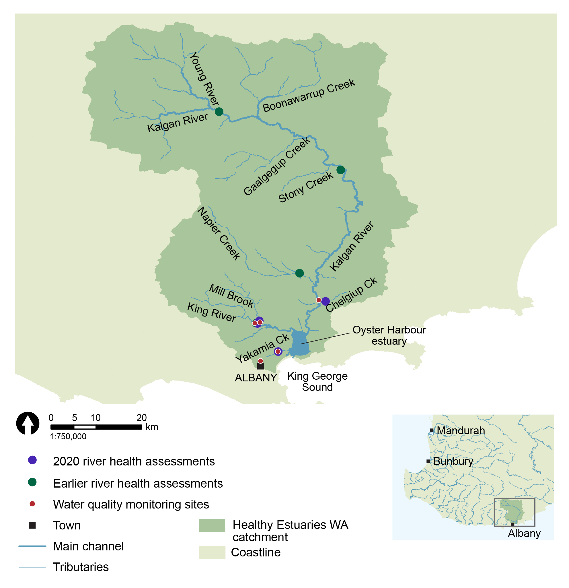
Since 2008, a total of eight river health assessments have been carried out throughout the Oyster Harbour catchment under the Department of Water and Environmental Regulation’s (the department) ongoing program. This includes targeted assessments during the 2017-20 Regional Estuaries Initiative to investigate key areas of the catchment that previously had little or no data. Information from these assessments was examined under the Regional Estuaries Initiative to assess the status of values and threats.
Based on historical data, the Oyster Harbour catchment was found to have reasonably high native biodiversity, with 15 species of native fish and crustaceans observed. This included eight species of native freshwater/freshwater-estuarine fish, the pouched lamprey, which migrates from the ocean into the headwaters of rivers to spawn, and four species of freshwater crustaceans (crayfish and shrimp). Ten of these species are endemic to the South West of Western Australia (WA), which means that these species are not naturally found anywhere else.
At the sites sampled in the 2020 assessments on Chelgiup Creek, King River and Mill Brook, the biodiversity was found to be in generally good condition, as was the water quality and aquatic habitat. In contrast, significant issues were identified for the Yakamia Creek site, many of which are known and are the subject of ongoing rehabilitation and restoration efforts.
The 2020 assessments highlighted important ecosystem values, but also several pressures on the health of the river ecosystems, including:
- Historic clearing reflecting urban, cropping and grazing land uses in the catchments. The loss of vegetation, particularly through the stream corridor, is having an impact on water quality and habitat. Issues include:
- Low dissolved oxygen concentrations
- High nutrient and metal loads
- Loss of complex in-stream shelter particularly woody habitat
- Presence of exotic fish and crayfish species, which influence native species through competition, predation, and changes to habitat
- Access to rivers by livestock resulting in:
- Erosion, contributing to sedimentation
- Loss and trampling of fringing vegetation
- Potential water quality issues and an increase in nutrients entering the waterway.
Of note was that the Yakamia Creek site was dominated by exotic fish and crayfish species. Native species are adapted to natural conditions and under pristine conditions are highly resistant to introduced species, whereas invasive species are typically able to tolerate a wider range of conditions and have a significant advantage in impacted systems. The exotic species in Yakamia Creek is a clear reflection of suboptimal conditions and suggests the creek is under higher stress in comparison to the other river systems in the Oyster Harbour catchment. The habitat and water quality within Yakamia Creek was observed to be in poor condition, which supported this assessment.
Recent assessments were not an exhaustive survey of the current status of the entire catchment. New data now adds to our knowledge base of how WA river systems function in different circumstances. Data also provides a baseline for ongoing monitoring of river health in the catchment.
River health assessments
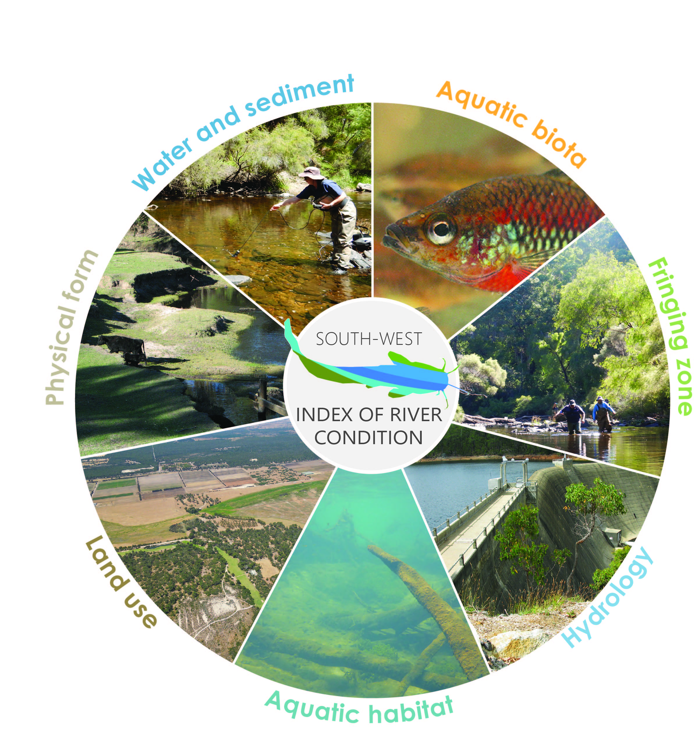 River health assessments were carried out using the
 In 2008, river health assessments were conducted on the Napier Creek, King River and two sites along the Kalgan River (Burnside Road and Takalarup Road).
Under the Regional Estuaries Initiative, assessments of river health through the Oyster Harbour Catchment were conducted at four sites in the lower part of the catchment in March 2020. The waterways sampled were Yakamia and Chelgiup Creek, the King River and Mill Brook.
The site names for the assessment sites were:
- Andrews Road (Chelgiup Creek - tributary of the Kalgan River)
- Old Millbrook Road (Mill Brook - tributary of the King River)
- Billa Boya (King River)
- Lower King Road (Yakamia Creek)
Additional traps were set at a site on Wilyung Creek.
Aquatic biota
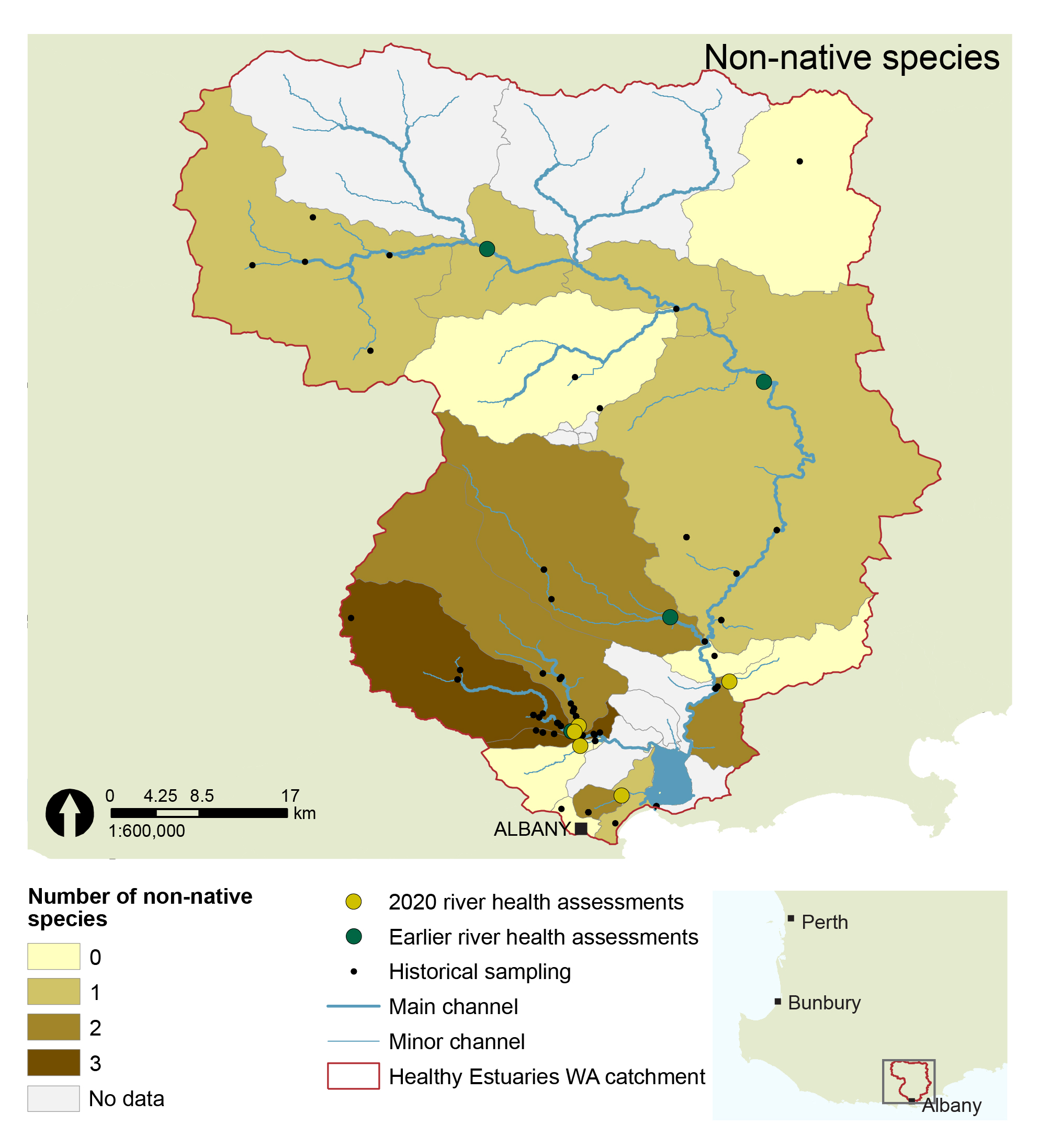
Based on available historical data, 15 species of native fish and crustaceans (crayfish and shrimps) have been found within rivers of the Oyster Harbour catchment. This includes: eight species of freshwater/freshwater-estuarine fish plus the pouched lamprey, which migrates from the ocean into the headwaters of rivers to spawn; two estuarine fish species that opportunistically enter the freshwater parts of rivers to forage (bream and mullet); three species of freshwater crayfish; and one species of freshwater shrimp. Ten of these species are endemic to the South West of WA, which means that these species are not naturally found anywhere else. Three species are of conservation significance (mud minnow, trout minnow, and pouched lamprey). Five exotic fish and crayfish species have been found.
Turtles and rakali, or native water rat, also occur through the Oyster Harbour river systems. Click on the images below for more information.
Other estuarine and marine species are known to occur in the lower, tidally influenced sections of the system, including yelloweye mullet, tommy ruff or Australian herring, estuarine cobbler, tarwhine, whiting and blue swimmer crabs. These species are not considered in river health assessments because they do not live in the upstream rivers.
Native species (Click for more information)
Green border indicates species with conservational significance
Western pygmy perch
Blue-spot goby
Nightfish
Western minnow
Trout minnow
Western mud minnow
South-west goby
Black bream
Sea mullet
Jollytail
Lamprey
Gilgie
Smooth marron
Koonac
(New species to be identified)
Cherax sp. novel
South-west glass shrimp
Water rat (rakali)
South-western snake necked turtle
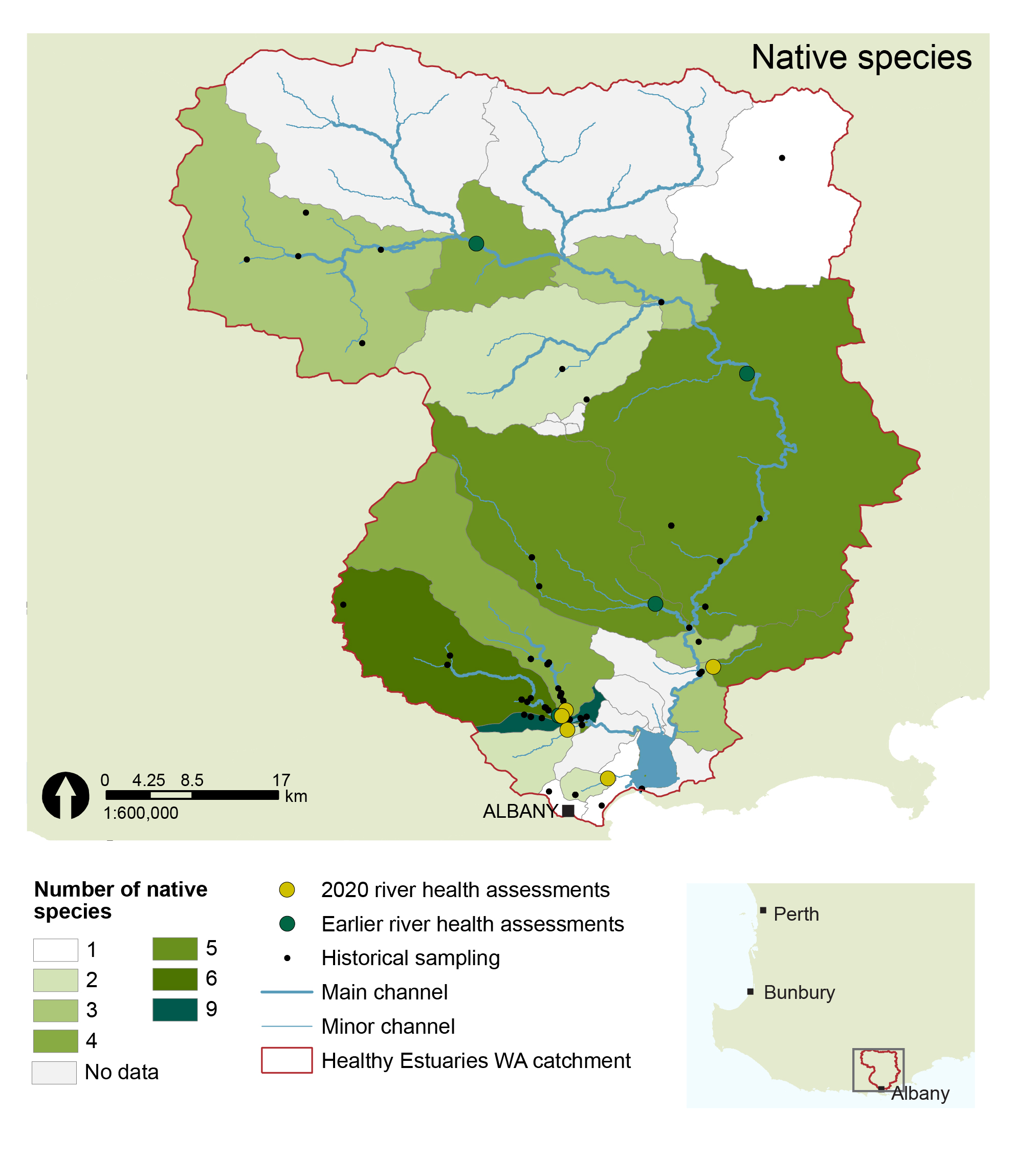
For the 2020 river health assessment sites, the freshwater fish and crayfish species i(including western pygmy perch, western minnow, nightfish and koonacs) that were expected within the subcatchment were found, with exception of Yakamia Creek. Smooth marron were found in the King River and Chelgiup Creek. Juvenile western pygmy perch and nightfish were found at Chelgiup Creek, suggesting appropriate habitat for successful breeding within the system. Freshwater/estuarine species, blue spot goby and southern black bream, were detected at the King River assessment site.
Evidence of rakali was found at Chelgiup Creek, based on crayfish consumed in some of the traps. Rakali have been used as a bio-indicator for wetland health because they live in better quality wetland habitats.
Rainbow trout were found at King River and Mill Brook, these non-native fish are introduced to the system, along with brown trout, for recreational fishing.
Yakamia Creek was dominated by non-native species, with many eastern gambusia (exotic freshwater fish) and an individual yabby detected. Only one western pygmy perch and one nightfish were captured. Dominance of eastern gambusia suggests the system is under stress. This species of fish competes for food and habitat and can thrive in disturbed and degraded systems. Two south-western snake-necked turtles were also found at this assessment site.
See more information on each of the species.
Hydrology and landuse
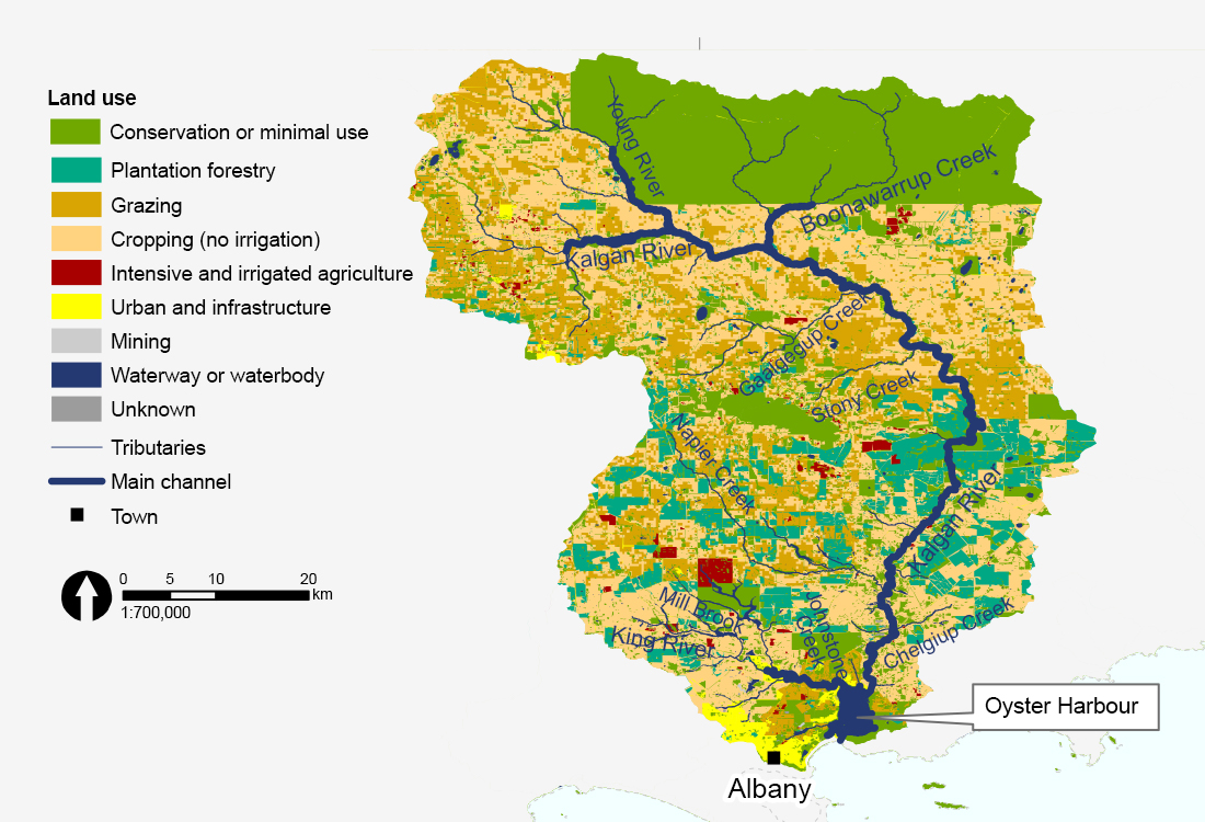
Land use categories represent groups of common land use based on similar influences to river ecosystems as defined in the SWIRC (Land use dataset: Catchment Scale Land Use Mapping for Western Australia 2018)
About 70 per cent of the Oyster Harbour catchment (3,000 km2) has been cleared. Land use includes cropping, grazing, plantation forestry and a small amount of intensive and irrigated agriculture. The uppermost part of the catchment is the conservation reserve Stirling Range National Park, with fringing vegetation of the tributaries within this area being relatively natural.
The two largest rivers are the King and Kalgan Rivers. The Kalgan River flows for 140 km before entering the north-eastern corner of Oyster Harbour. The Kalgan River has elevated salinity (marginally saline to brackish) due to extensive clearing in the upper catchment, with the last 9 km of the river influenced by ocean tides. The main tributaries include Young River, Napier Creek, Boonawarrup Creek, Stony Creek and Gaalgegup Creek.
The King River flows for 27 km before entering the north-western corner of Oyster Harbour. Despite the clearing within the catchment, the waters of the King River are relatively fresh. The last 7 km of the river is influenced by ocean tides. The main tributary that flows into the King River is Mill Brook, which runs through a nature reserve and joins the King River about 2 km north-west of the Upper King bridge.
Vegetation, physical form and habitat
The channel form of the King and Kalgan rivers is mostly natural, however some sections have been straightened and deepened to support agricultural water supply and drainage.
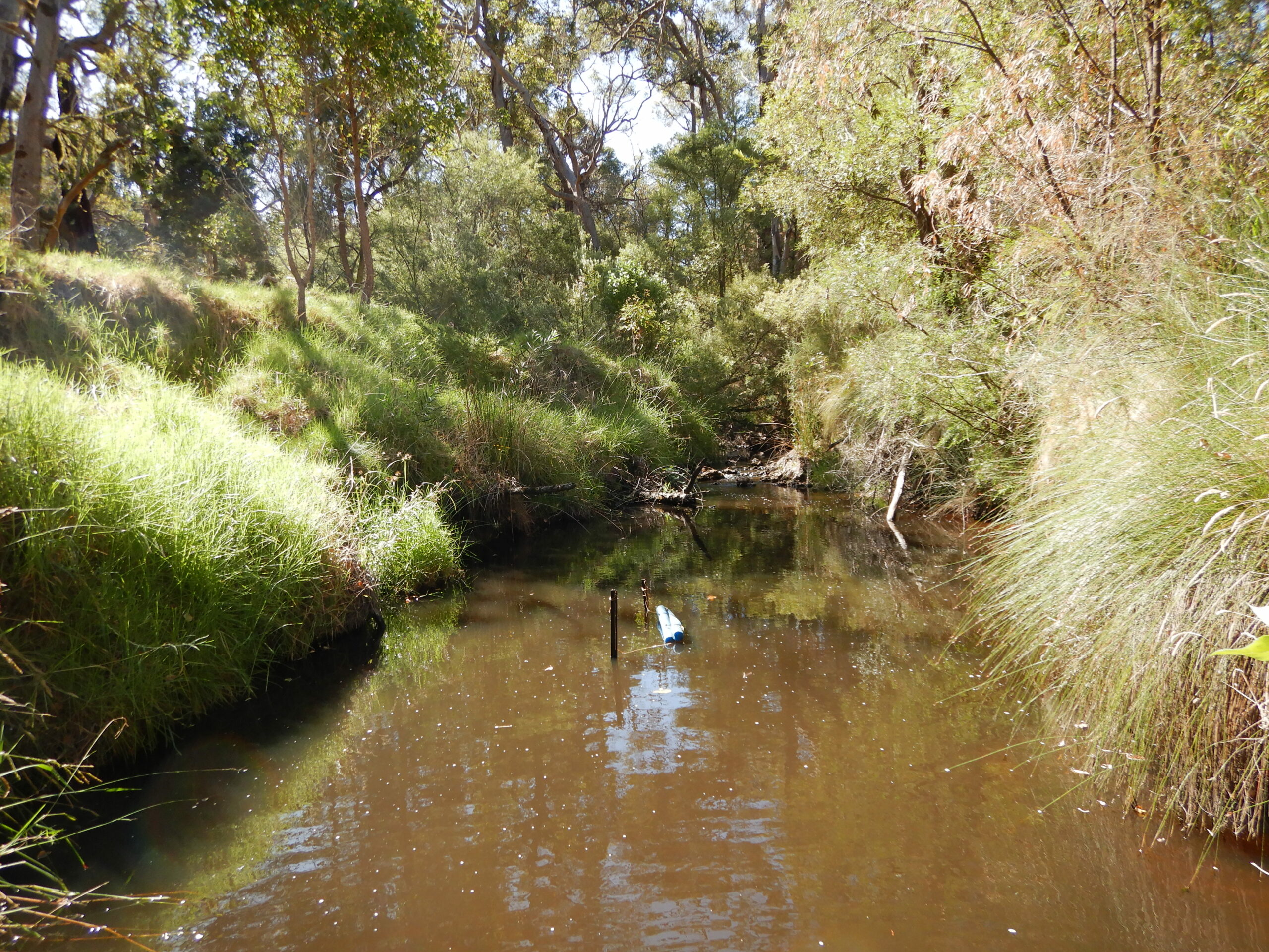
The fringing vegetation at all the sites assessed in 2020 was characteristic of many agricultural catchments across the South West, with a reduction in width due to clearing, and invasion of exotic species particularly through the ground and shrub layers. A large variety of exotic species were present across the different sites, with pasture grasses, taylorina, blackberry bush and Sydney golden wattle common across most of the assessment sites. Remnant vegetation differed across the sites with only tea tree being the common species between all sites. Marri and flooded gum were observed along the King River, and paper bark trees were present at Yakamia and Chelgiup Creeks. The Yakamia Creek has been heavily modified from its natural state. Restoration work has been on-going within the Yakamia Creek subcatchment to help re-establish habitat and riparian vegetation along the Creek channel. The Fish Friendly Farms and Yakamia Creek biofiltration projects have been developed to rehabilitate parts of Yakamia Creek.
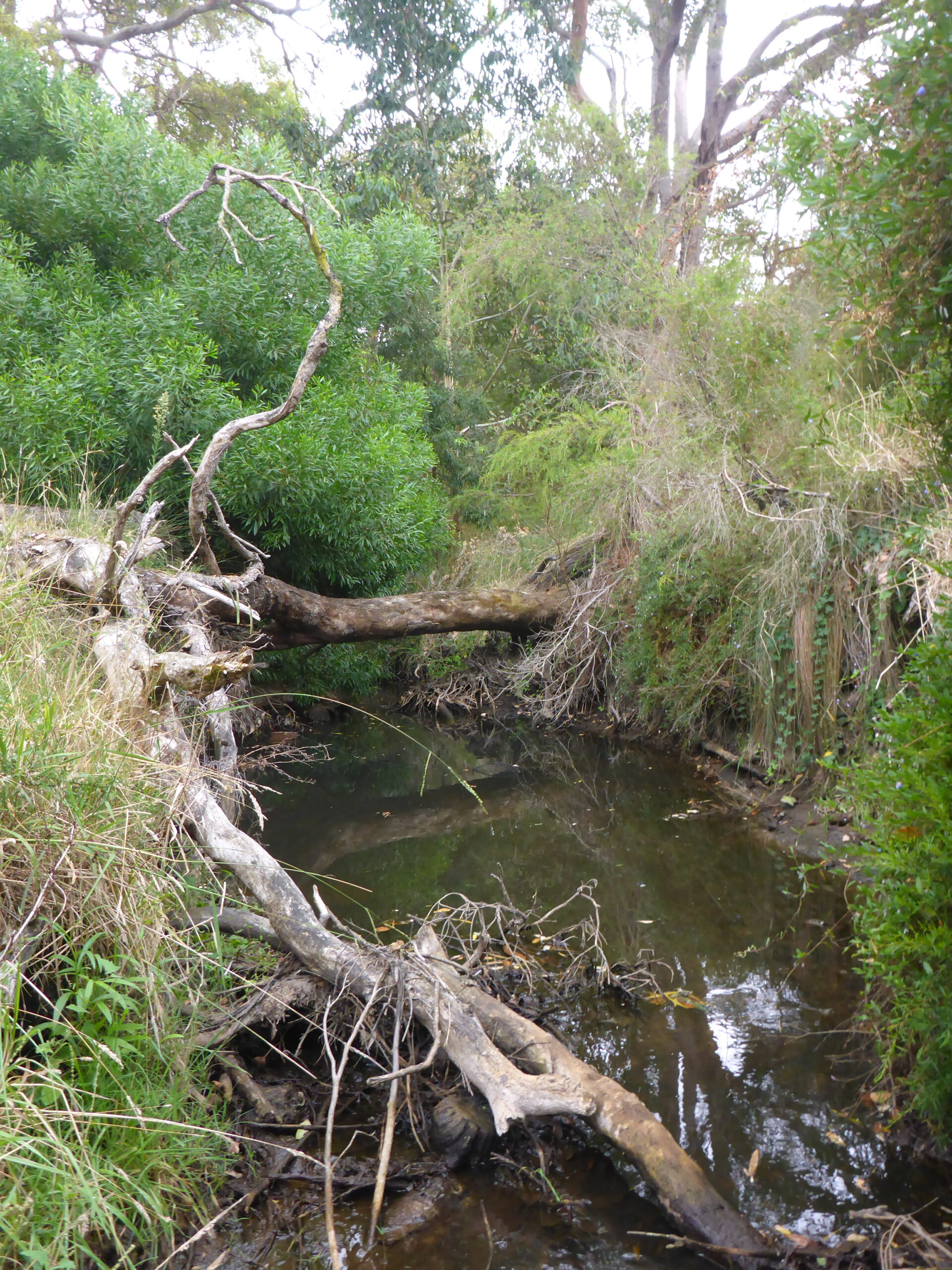
Stream habitat varied between the different assessment sites. Yakamia Creek provided limited habitat compared to other sites, which is consistent with historic channel modification and clearing, resulting in reduced tree and shrub vegetation fringing the site. Chelgiup Creek, Mill Brook and King River sites had a moderate to dense abundance of woody debris, which provides essential habitat for freshwater fish and crayfish. In contrast, the limited woody structure within Yakamia Creek provided limited refuge for aquatic species, particularly to avoid being displaced under high flows. Chelgiup Creek, Mill Brook and King River all had overhanging roots and overhanging vegetation draped in water, providing additional habitat and shelter for fish. The Yakamia assessment site had no overhanging roots and only small areas of draping vegetation.
Overhang from trees, shrubs and grasses lining the riverbanks provide shade, physical habitat and food, which is important to maintain water temperature, particularly during the summer months. Chelgiup Creek, Mill Brook and King River assessment sites had tree, shrub and grass overhang that covered 50-95 per cent of the bank lengths. The assessment site at Yakamia Creek only had grass overhang along most of the lengths of the bank.
Water quality
Dissolved oxygen levels were within optimal ranges for freshwater fish (>4 mg/L) at each of the assessment sites except Yakamia Creek. Low dissolved oxygen levels at Yakamia Creek are likely to have contributed to the low number of native fish and absence of crayfish. Many eastern gambusia were found within Yakamia Creek - this exotic species can thrive in degraded systems due to their greater tolerance to poor water quality compared to native fish. In this case, their higher tolerance to low dissolved oxygen concentrations has contributed to their survival.
The water temperatures at each assessment site were within optimal conditions, ranging between 17°C to 21°C. The South West Index of River Condition uses a maximum water temperature threshold of 25°C and a daily variation in water temperature of no more than 4°C (above which the aquatic ecosystem is expected to experience increasing levels of stress).
Many of the freshwater species are generally found in water with salinity below 2,500 mg/L. Some freshwater fish are not able to tolerate salinity above this level, and all species would be expected to be under increasing levels of stress as salinities increase beyond the upper range. Salinity (TDS) recorded at assessment sites ranged from fresh to brackish (470 mg/L to 2,430 mg/L). The upper salinity range is not uncommon across the Oyster Harbour catchment due to historic vegetation clearing. At the time of sampling, Yakamia Creek had the freshest water, Chelgiup Creek was marginal to brackish, and the highest salinity (brackish) was recorded in Mill Brook.
Salinity data was not collected at the King River assessment site, due to a logger error. However, as part of the Regional Estuaries Initiative and the Healthy Estuaries WA program, nutrients, salinity, pH and other parameters are regularly monitored on the King River, Mill Brook, and Yakamia Creek, at sites close to the river health assessment sites. Water quality is also monitored on the Kalgan River, just below the confluence of Chelgiup Creek. The water quality in river health grab samples in March 2020 was consistent with the Healthy Estuaries WA concentrations recorded nearby. The long-term monitoring data indicated King River water was fresh (<500 mg/L) at the time of the 2020 river health assessment. Seasonal and long-term trends are detailed in the Healthy Estuaries river monitoring data.
River health assessments in March 2020 showed concentrations of nutrients (total nitrogen and total phosphorous) were below the ANZECC (2000) trigger values for lowland rivers in South West WA (TN = 1.2 mg/L; TP = 0.065 mg/L). The exception was total nitrogen in Chelgiup Creek (1.6 mg/L), which exceeded the trigger value. The long-term monitoring data also indicates nutrient concentrations in these systems typically increase in the winter months. Moderate to high concentrations of nutrients are generally indicative of eutrophication or excess nutrients which can be linked to several local and/or catchment wide land uses. Excess nutrients in a waterway can potentially cause excess growth of algae, which in turn impacts water quality particularly dissolved oxygen.
Samples for heavy metals concentrations were collected in Yakamia Creek based on past elevated concentrations of some metals, associated with local urban land use. Aluminium and iron concentrations were found to exceed ANZECC water quality guidelines.
Find out more about Healthy Estuaries WA and Regional Estuaries Initiative projects to improve water quality of areas including Yakamia Creek here.