

Estuaries are special places that support the unique lifestyles of many Western Australians. Many towns and cities were established near rivers and estuaries, due to the reliable sources of fresh water, safe anchorages, and an abundance of food. The majority of Western Australians now live close to estuaries, or within their catchments.
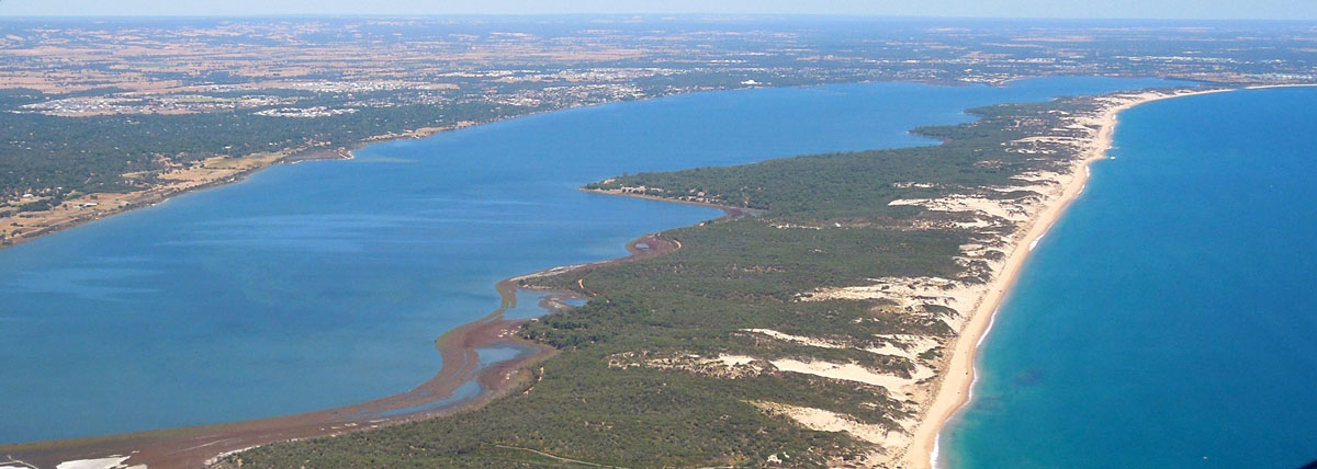
Unfortunately, many of the 40 estuaries in South West Western Australia are in poor or declining health. The most immediate and direct human impact is eutrophication, where the oversupply of nutrients causes an excessive growth of plants and algae, pushing the ecosystem out of balance. Healthy Estuaries WA aims to improve health in seven of the most at-risk regional estuaries – the Peel-Harvey, Leschenault, Vasse-Wonnerup, Hardy Inlet, Wilson Inlet, Torbay Inlet and Oyster Harbour.
These water bodies have cultural and spiritual values, particularly for our Aboriginal population for whom these water bodies are nurturing, life-sustaining, sacred and integrally intertwined with their being. These areas are sanctuaries within but also removed from the frenetic, fast-paced urban lifestyles. Estuaries are also highly valued for natural open space, aesthetic qualities, tranquillity and peacefulness:
- the tranquillity and peacefulness make them desirable places to live and people are willing to pay a premium to live near the water
- they provide a wide range of recreation opportunities – swimming, boating, fishing, crabbing, walking, cycling, kayaking, stand-up paddle boarding, kite surfing, bird watching, picnics and barbeques.
Unique environments and important habitats
Our local estuaries are internationally-recognised for their importance to migratory birds, and they contribute to the south west of Western Australia being recognised as one of the world's 35 biodiversity hotspots.
These partially-enclosed water bodies form transition zones between river and marine environments. Estuaries are influenced by the land and by the sea – with freshwater flow carrying sediments and nutrients, and tidal exchanges of seawater respectively. They are naturally dynamic environments.
Estuaries are among the most fertile and productive environments in the world. Their diverse range of physical habitats support a wide array of plant and animal communities by providing:
- permanent habitat for many species
- spawning grounds and nurseries for juveniles
- dispersal corridors
- migratory stopovers for birdlife.
Strong economies: trade, tourism, fisheries and natural infrastructure
- protection of shorelines and infrastructure from storm surges and floods
- natural treatment of pollution discharged from industrial, agricultural and urban activities.
Our engineering legacy
Our estuaries and their catchments have undergone rapid change over the last century or so. The ability of our estuaries to absorb these pressures has reduced over time, as the cumulative impact increases. We now need careful and active management to ensure values are sustained whilst enabling economic development and liveability of our estuaries.
Estuaries are influenced by a multitude of stressors:
- extensive drainage network has lowered the water table, draining wetlands and disconnecting related water bodies to facilitate agriculture in our catchments
- fresh water flow volumes have reduced due to water use for irrigation, industry and urban water supply
- diversion of natural flows for flood control
- increased sedimentation from land clearing, soil erosion and overgrazing
- increased pollutant and nutrient load from industrial, agricultural and urban waste
- loss of estuarine foreshore from hard-walling and canal developments
- overfishing, habitat destruction and the introduction of foreign species
- altered freshwater flow regimes from climate change – our estuaries are becoming more marine, and a shift in species distributions has been observed.
Aboriginal significance
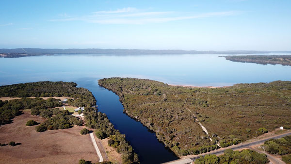
Peel-Harvey Estuary
The Peel-Harvey estuary sits inside the boodjar (country) of the Bindjareb (Pinjarup) Noongar people. The Binjareb people refer to the Peel-Harvey estuary as Djilba.
This is the ancient name used for thousands of years.
Djilba is also a name for one of the Noongar people’s six seasons and runs between August and September, straddling the western European seasons of spring and winter. Djilba is also a name for the fish, bream.
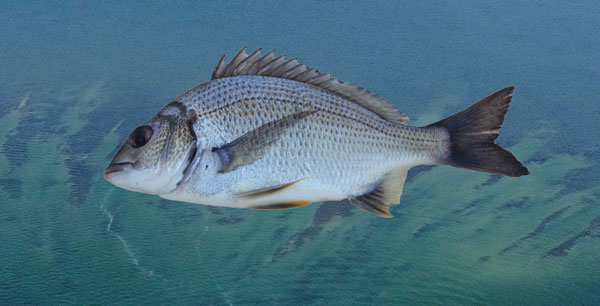
Djilba‘s values are associated with renewal and re-birth, including bream that start to spawn in the estuary around spring time each year.
According to the local Noongar people, the Peel-Harvey estuary, and all the rivers and lakes that are connected to it, were formed in the Dreamtime, when there was a drought on the land and the freshwater sources were drying up.
The Noongar creator being, the Woggaal, is associated with the creation of freshwater places in the Dreamtime. The Peel Inlet was created by the female aspect of the Woggaal, known as Maadjit, when she went inland from the sea to give birth to her children.
Other parts of the Peel-Harvey’s surrounding rivers, streams, lakes, waterholes, wetlands and springs were formed by Maadjit’s children or koolaangka as they left the estuary and travelled throughout the country leaving their own marks and trails.
Finally, the remainder of the waterways were formed by Maadjit as she searched for what became of her children.
Djilba‘s values are associated with renewal and re-birth, or what we would refer to as spring values. Djilba’s values are also specifically referred to by some Noongar groups as incorporating the ‘second rains’ that ‘fill lakes and waterholes.’
Djilba is also one of the Noongar names for bream, which live and are abundant in the south west waterways, including the Peel-Harvey, and which start to spawn in the estuary around spring time each year.
In cultural knowledge, the relationship between the environmental values of Djilba and the Dreamtime story of the creation of the Peel-Harvey Estuary system are clear. The birth of the spirit children of Maadjit comes at a time of drought, and through the birth and subsequent life of the children, new freshwater rivers and waterholes are created, and the fertility of the land is re-set.
The values of bream are also elegantly embodied by Djilba. Bream were, and remain, a major food source of Noongar people. They start to spawn during the sixth Noongar season, and unlike many species that give birth in estuaries only to move to ocean, the bream spend their entire lives in the estuary, where the ebb and flow of saltier and fresher water plays a key role in the timing of its movement and life cycles.
In respect to the Maadjit, the Murray River is called Bilya (River) Maadjit (Female Creator) therefore the bridge where the Kwinana Freeway ends and where Forrest Highway begins is named Bilya Maadjit.
*Cultural informants George Walley, Cultural Knowledge Holder, and Joseph Walley, Senior Elder and Cultural Knowledge Holder (RIP).
Leschenault Estuary
Leschenault estuary is in the boodjar (country) of the Wadandi Noongar people, and is known as Derbal Elaap.
Derbal means estuary and Elaap refers to the territory of the Elaap clan group of the Wadandi tribe or Yoongan Jarli Elaap (People of Elaap).
This district was known also known as home to the Cultaa Yoongan Jarli (Mullet people). Both Yellow Eye (Aldrichetta forsteri) and Sea Mullet (Mugil cephalus) use the Leschenault estuary as a nursery area.
*Cultural informants Undalup Association /Zac and Wayne Webb.
Elaap refers to Yoongan Jarli Elaap - People of Elaap.
Vasse Wonnerup
A women’s digging sticks (Wonna) are made from the wood of the Peppermint Tree or Wannang prevalent in this area.
The Vasse-Wonnerup estuary is in the boodjar (country) of the Wadandi Noongar people.
Wonnerup in Wadandi language means place of the woman’s digging stick or Wonna. Wonna are made from the wood of the Peppermint Tree or Wannang, which are a feature of this area, and is used for digging up native potatoes, carrots, chillis and other food.
There are Wadandi fish traps (mungah/mungar) recorded at both the Vasse River entering the estuary and the Abba River.
The Vasse end of the estuary has been referred to as Menbinup.
The Capel River used to flow into the Wonnerup estuary before it was diverted to the coast at the Higgins Cut. This area is known as Mallokup, which means a place of shadows and shade (Malo). It is also known as a place of the black swans (Mali/Marlee), and is one of the largest breeding grounds in Western Australia for this species.
*Cultural informants Undalup Association /Zac and Wayne Webb. With published research from Professor Len Collard and Noongar Dictionary (1992 Noongar Cultural Language Centre).
Hardy Inlet
Hardy Inlet is in the boodjar (country) of the Wadandi Noongar people. The area where the Blackwood River turns into Hardy Inlet and runs to Flinders Bay is Talinup, which is named after the Talin or Knob Sedge (Carex inversa), a bush/reed that appears on the estuary shores.
Goorbilyup is the Wadandi name for the lower Blackwood River entering to the estuary, with Goorbilya meaning the large intestine of the stomach.
This is part of the Emu (Waitj) dreaming trail that starts at Lake Dumbleyung and where the town of Wagin gets its name from. It is noted that in modern times Emu oil is considered to promote intestinal health and reduce bowel disease.
*Cultural informants Undalup Association/ Zac and Wayne Webb.
Goorbilyup is the Wadandi name for the lower Blackwood River entering to the estuary.
Wilson Inlet
Jennalup where the Hay River runs into the Wilson Inlet
Wilson Inlet is in the boodjar (country) of the Menang Noongar people. The peninsula that separates the estuary from the ocean and creates Wilson Inlet is known as Nullaki, which means narrow place of seaweed.
Jennalup is the name for the area where the Hay River runs into the Wilson Inlet, and means place where you can cross by foot.
Kwoorabup means place of the western brush tailed wallaby (Macropus irma) which is called a Kwoora, and refers to the area where the Denmark River runs into the Wilson Inlet.
The inlet is known as a place of Djiljit Boola (fish plenty)
*Cultural informants Undalup Association /Zac and Wayne Webb in consultation with Menang elder Harley Coyne.
Oyster Harbour
Oyster Harbour is in the traditional lands (boodjar) of the Menang Noongar people and is known as Miaritch – which refers to the meeting place of the Warrecoolyup (King) and Kalganup (Kalgan) rivers, and also a meeting place of the Menang people. It is also known as the ‘home of all the fishing traps’, or mungas, with the land area adjacent to the traps known as Tamungup.
Today there remains eight fish traps on the northern shoreline of the harbour which are under the protection of local Menang people through the Albany Heritage Reference Group Aboriginal Corporation with the help of local and state government.
*Cultural informant Vernice Gillies/Museum of WA (Albany).
Tamungup is known for its fishing traps, or mungas.