Water Quality
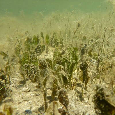
The Leschenault Estuary is uncharacteristic of permanently open estuaries due to its long narrow shape and the location of the Collie and Preston river inflows on its south side opposite “the cut”. It is also consistently very shallow through the main basin (<2 metres). Before “the cut” was built (i.e. before 1951), the estuary was mostly brackish during winter. However increased marine exchange through this artificial opening has resulted in the estuary becoming predominantly marine in salinity. During summer, the northern estuary can reach salinity concentrations nearly twice that of seawater due to evaporation.
Freshwater flows to the estuary have also altered with both declining rainfall and restriction in flows due to the construction of dams in the catchment, such as the Wellington dam. With the reduction of freshwater flows, salinity stratification (the layering of fresh water over more saline water) is more prolonged in the estuarine rivers of the Collie, Brunswick and Preston. Here, release of nutrients from the bottom sediments is evident and low oxygen in the water is common. These conditions favour phytoplankton blooms, and can result in fish deaths.
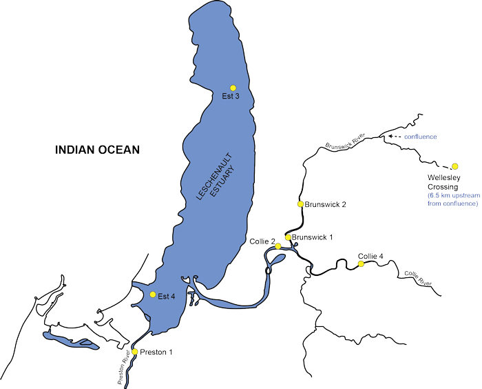
Figure 1 – Median (point) and 80% of data for surface and bottom dissolved oxygen concentrations. Data collected from October to May (dry season) during 2006 to 2009.
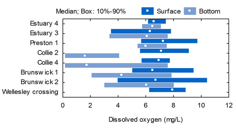
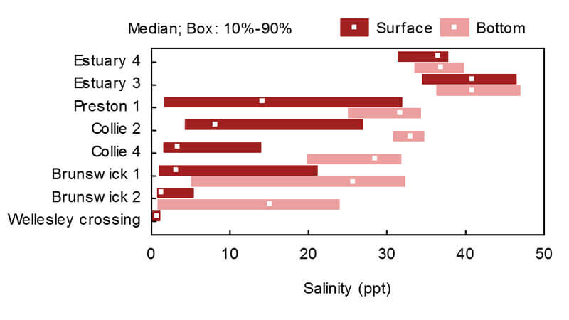
Figure 2 – Median (point) and 80% of data for surface and bottom salinity for monitored sites in the estuary and estuarine reaches of the rivers. Data collected from October to May (dry season) during 2006 to 2009.
Water quality data collected between 2006 and 2009 was summarised in the Leschenault Water Quality Improvement Plan – see figures. The Healthy Estuaries WA is supporting the collection of current water quality data in our estuary. Recently collected water quality data can be obtained by visiting the Department of Water and Environmental Regulation’s Water Information Reporting.
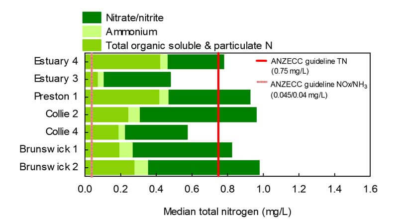
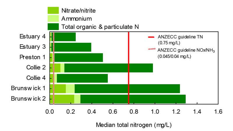
Water quality in the main estuary basin is better than in the estuarine rivers. The median values for the data from the sites in the main estuary body are generally acceptable, with the exception of dissolved oxygen. Median values for the sites in the estuarine sections of the rivers more commonly exceed the recommended guideline values with high concentrations of nutrients and low dissolved oxygen. The two sites in the Brunswick River estuary and Collie 2 (6121166) in the Collie River estuary have very poor water quality. They exceed the chlorophyll-a guideline by a factor of two, have high median nitrogen and phosphorus concentrations and periods of anoxia or hypoxia. The high ammonium concentrations most likely indicate sediment release of ammonia in low oxygen conditions.
Many of the ecological problems in the Leschenault Estuary and estuarine reaches of the rivers are seasonal and not captured by examination of median values alone. The lower Collie and Brunswick rivers have consistently very poor water quality for most of summer and autumn.
In partnership, CSIRO and the Department of Water and Environmental Regulation have created a hydrodynamic computer-based model of the Leschenault Estuary. The model helps us understand how aspects of water circulation and freshwater inflow (timing and quantity) can influence residence time of the water. This helps us understand the fate and likely impacts of nutrient loads delivered from the Leschenault catchment to the estuary.
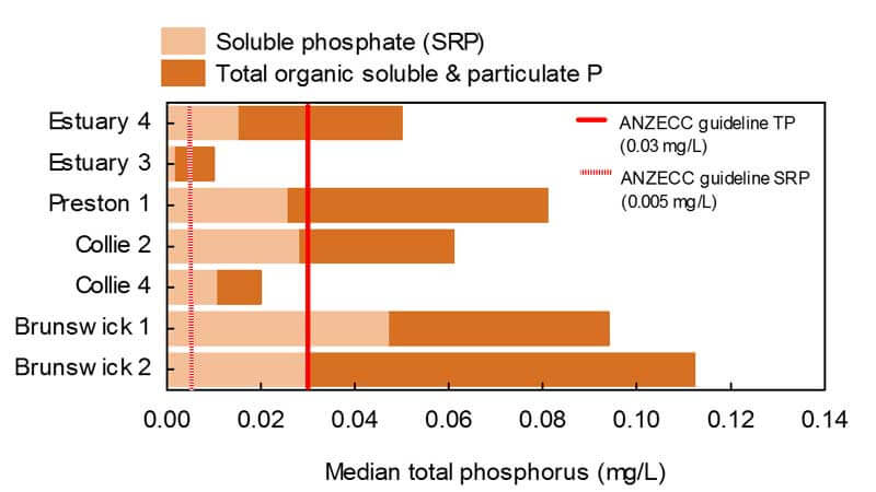
Figure 3 – Median dry season (October to May between 1998 and 2003) and wet season (June to September between 1998 and 2003) nitrogen and phosphorus concentrations in the estuary and estuarine reaches of the Brunswick, Collie and Preston rivers. The stacked bar indicates the relative proportions of different nitrogen and phosphorus forms.
a) Median dry season N concentrations
b) Median wet season N concentrations
c) Median dry season P concentrations
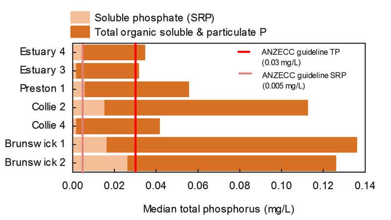
d) Median wet season P concentrations